Command Palette
Search for a command to run...
Zhejiang University Team Develops Earth Explorer System to Explore deep-time evolution/geological profiles/scientific Research Scenarios and Enable deep-time Earth Science Research

Deep-time earth science research focuses on the long history of the Earth, exploring the geological evolution process from billions of years ago to the present. The research scope is wide, covering key areas such as the Earth's internal structure, material composition, life evolution, and the interaction between the Earth and the external environment. In recent years, the demand for multi-dimensional space-time interactive analysis in geoscience visualization analysis methods has increased, and the rapid development of technologies such as big data, artificial intelligence, and high-resolution imaging has brought new development opportunities for the realization of deep-time earth digital twins.
Recently, at the 2025 Annual Academic Meeting of the Geographic Model and Geographic Information Analysis Committee of the Chinese Geographical Society, Qi Jin, a full-time researcher from Professor Du Zhenhong's team at Zhejiang University,The deep time visualization analysis system (Earth Explorer) was introduced at the special topic of "Deep Time Earth Crowd Intelligence Collaborative Innovation Platform", and the team's achievements were introduced from three aspects: overall overview, R&D progress, and scientific application results.
HyperAI has compiled and summarized Mr. Qi Jin’s in-depth sharing without violating the original intention. The following is the transcript of the speech.
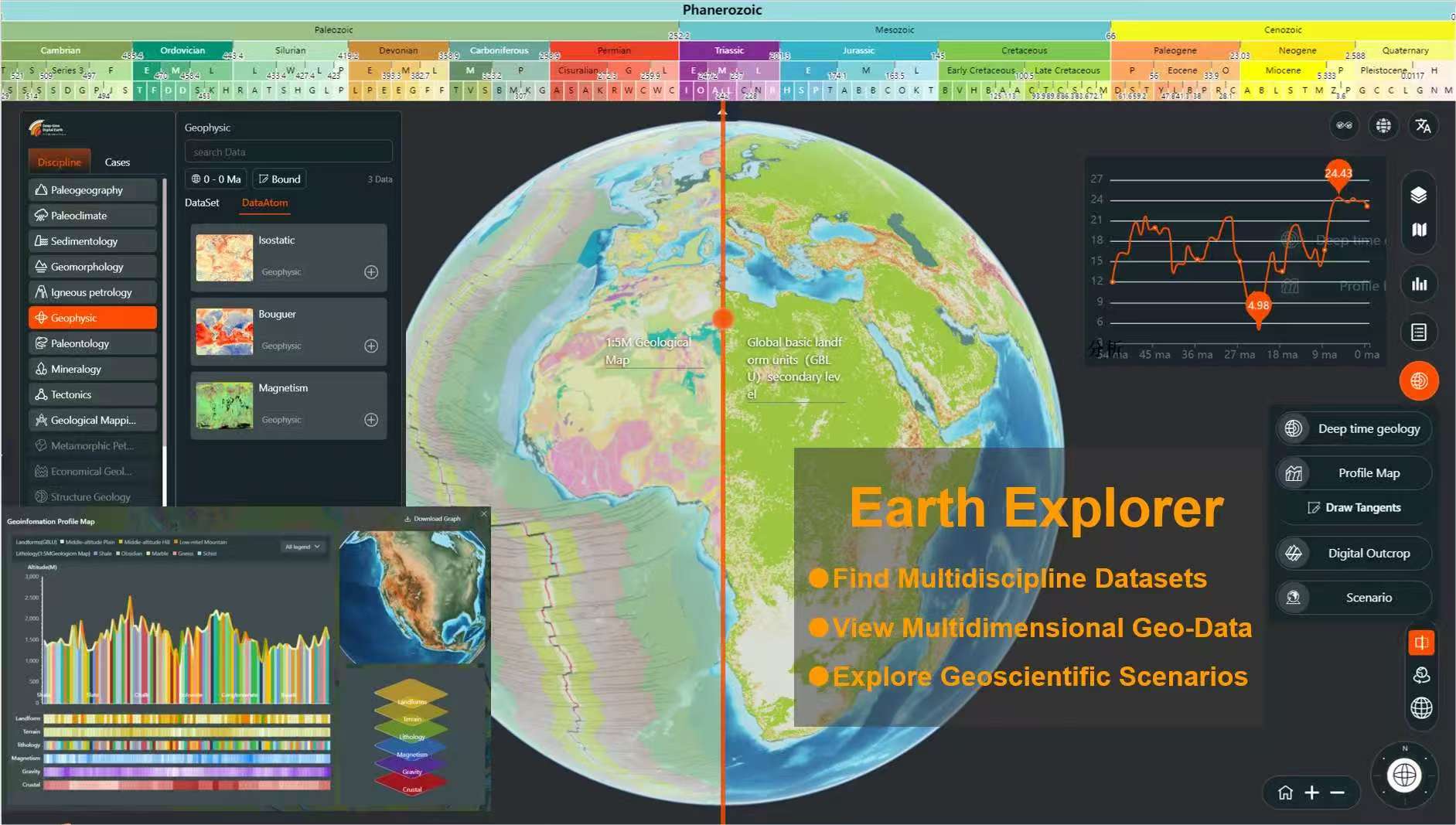
Earth Explorer: An online geoscience professional visualization analysis system
As the research methods and information technology of earth sciences change with each passing day, deep-time earth science research has put forward higher requirements for visualization analysis. In the Deep-Time Digital Earth (DDE) International Big Science Program, the DDE platform is guided by the big science problem of deep-time earth evolution, with big data, artificial intelligence, and digital twin technology as the core, focusing on how to enable deep-time earth science research.The visualization method that once relied on hand-drawn maps and two-dimensional static analysis now requires deep-scale spatiotemporal dynamic analysis and multi-dimensional scientific analysis that integrates the ground and underground.For example, how to visualize and simulate massive amounts of data on a scale of millions of years is one of the difficulties and challenges faced by scientific researchers. It is also an excellent opportunity to promote the use of technology to serve science.
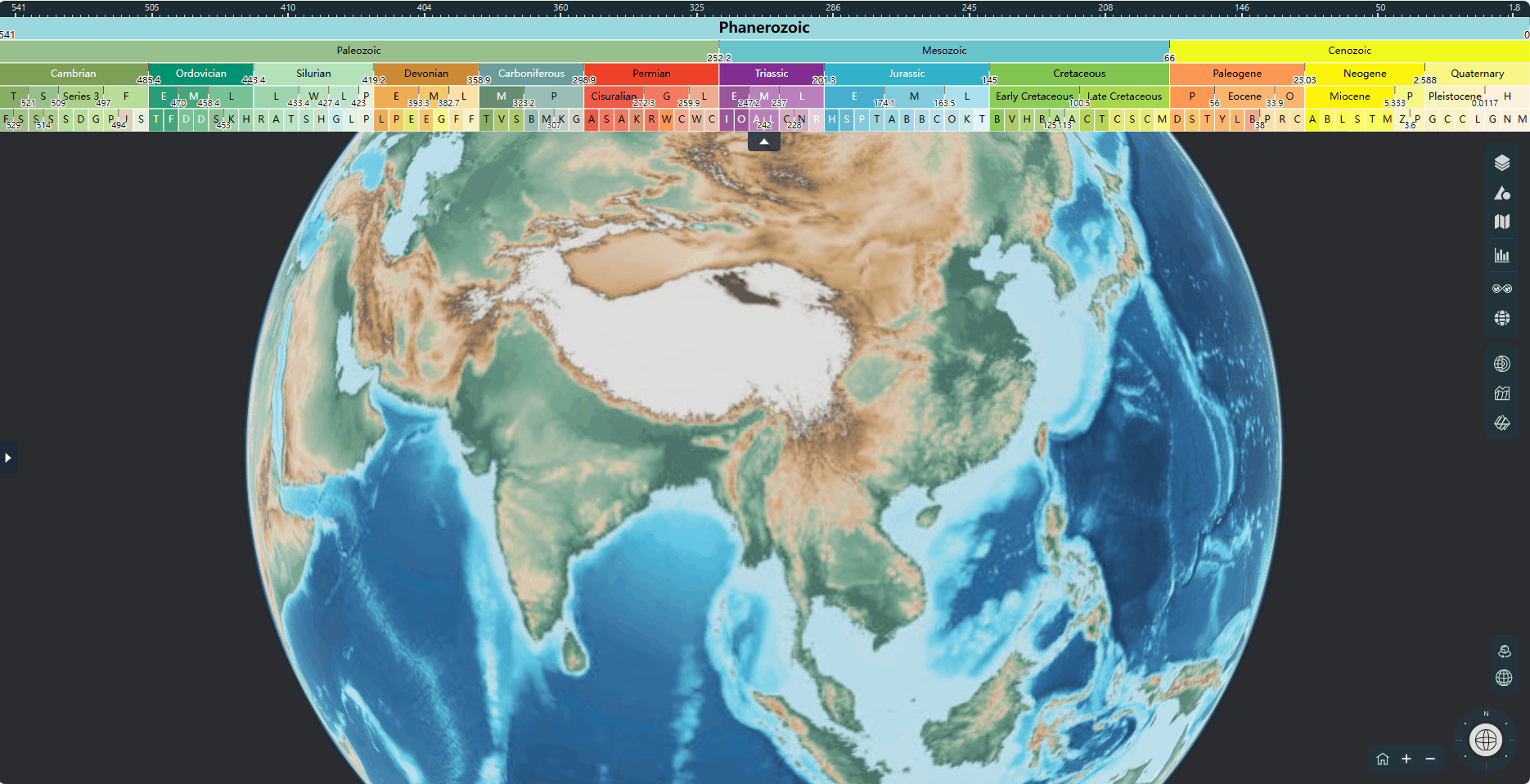
In this context, Earth Explorer (EE) came into being. As an online geoscience professional visualization analysis system serving earth researchers,EE utilizes and deepens the core technical capabilities of the DDE platform, such as Deep-Engine, and develops online multi-dimensional visualization rendering and spatiotemporal dynamic analysis capabilities for geoscientific data.Whether it is the three-dimensional earth, time series, spatial distribution, deep-time dynamic evolution, or geological profile analysis, it can easily control it and fully display the time, space, depth and spatiotemporal dynamic dimension changes of geological data. It is an important window for the DDE platform to display geological data.
The road to precision research: iterative upgrades based on demand
Earth Explorer was launched in December 2021, and its Alpha version was demonstrated and promoted to international scientists in Paris, France in 2022. Along the way, we found thatAn effective visual analysis system requires careful research, design, and operation from the perspective of scientist users.
Therefore, our team started by collecting requirements and conducted in-depth exchanges with more than 1,000 scientists to gather their needs and experiences. In addition, we also learned Internet product thinking, conducted a series of market analysis and user demand research, formed a complete product design document and development plan, and compiled user manuals and demonstration documents.
From 2022 to 2023, under the guidance of scientists, Earth Explorer developed more than 10 versions.We explored visual analysis systems suitable for different business scenarios, different subject habits, and different technical uses.The Alpha version realizes the spatiotemporal superposition, global retrieval and dynamic analysis of multi-source heterogeneous data. The spatiotemporal aggregation version classifies data according to different disciplines.It is convenient for scientists from various disciplines to find data and conduct cross-analysis, bringing new inspiration to scientific research.The team also built a three-dimensional earth development base.Scientists from different disciplines can quickly build their own visualization systems based on this technology base, reduce R&D costs, and achieve autonomous data management and display of scientific research scenarios.
The current version of space-time convergence has realized functions such as deep time evolution, geological profiles, and scientific research scene simulation.It assists scientists in conducting geoscientific spatiotemporal analysis on online maps, serving disciplines such as paleogeography and paleoclimate. Paleotemperature and paleoprecipitation are superimposed on this map for dynamic playback. It has also conducted research and demonstrations in Europe and the United States (EGU, AGU, etc.), Japan and South Korea (IGC, etc.), Africa (CAG), and other places, and has received positive feedback from scientists at home and abroad.
The EE system can efficiently visualize data from international programs such as DDE, and through dynamic analysis, present scientific research scenarios online to scientists at home and abroad.Next, our team also plans to create new functions that can upload geological models and geophysical methods to the EE system.
Powerful functions: Explore the business logic of "find data - view data - use data"
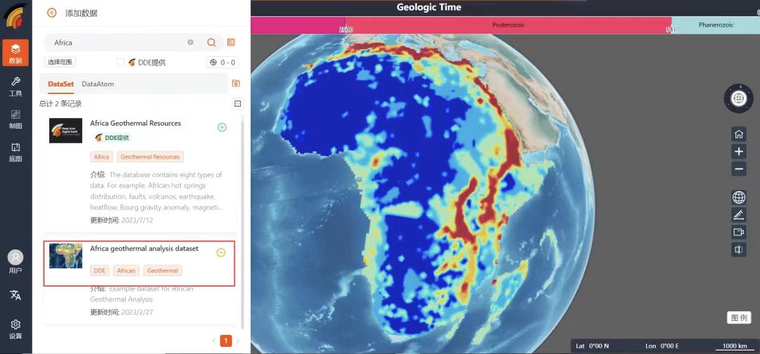
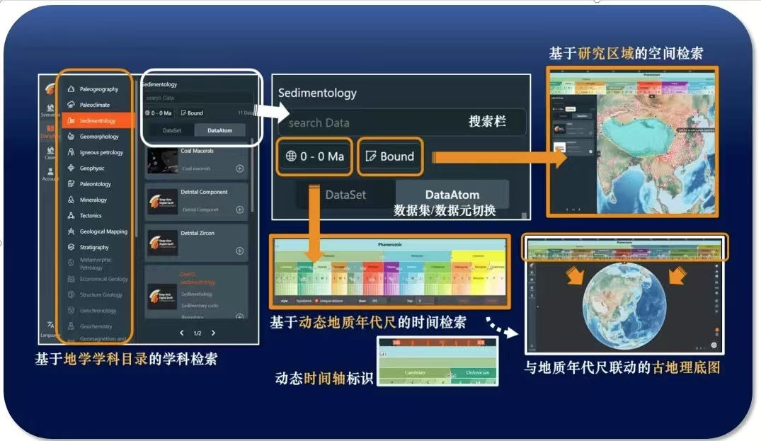
The first is the "Find Data" function. EE presets "Celebrity Data" in the data column.Such as global 1:500M geological maps, ultra-high-resolution geomorphological maps, deep-time paleoclimate simulation data sets, etc. The system can dynamically search based on time, space, and keywords. For some databases that have online links but are not publicly available, EE also supports adding custom data links and realizing online data loading in the form of data services.
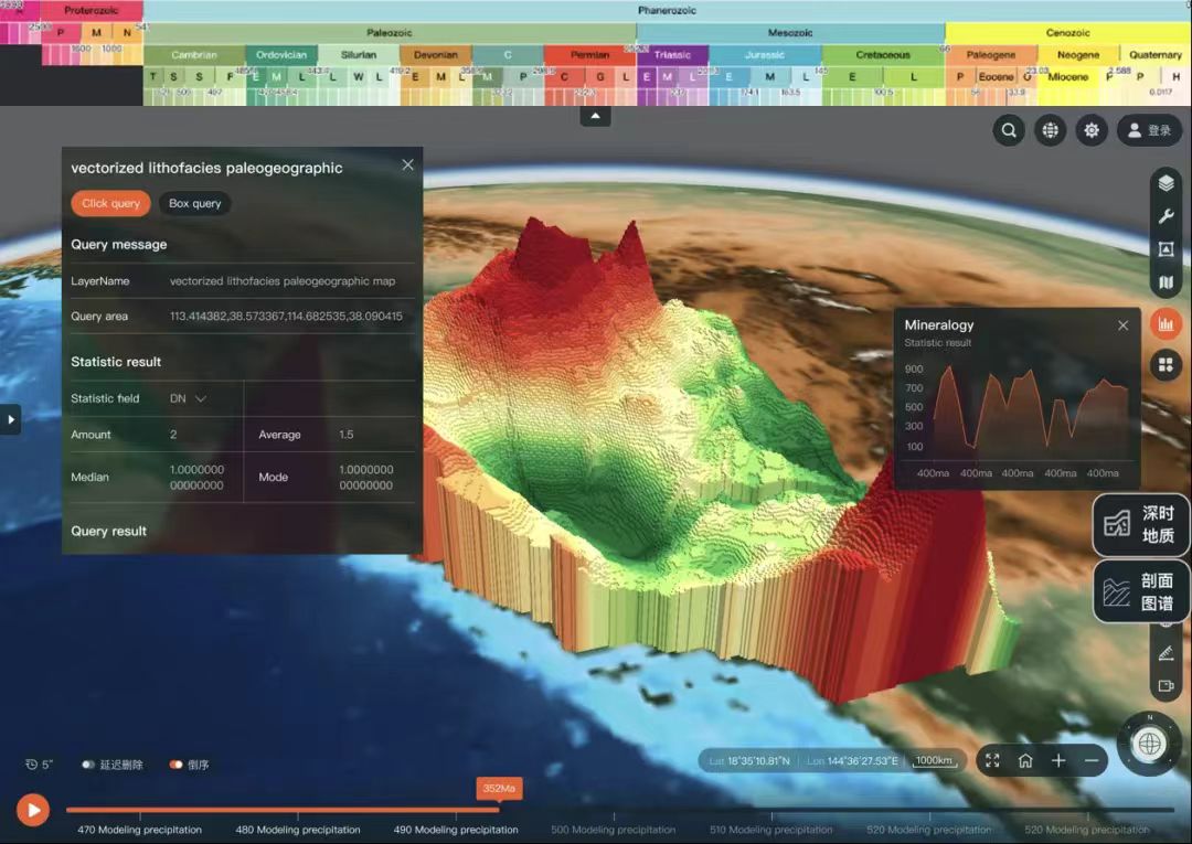
Secondly, in terms of "viewing data", EE provides a variety of functions including vector data rendering, raster data rendering, spatial attribute query, terrain visualization, 3D visualization, and profile visualization.Multi-source heterogeneous data can be loaded onto the map for access. For exploring certain specific areas, such as wildfires in California, the EE 3D visualization can be used to visually discover that "the middle part is dry, while the surrounding data has high humidity", thereby visually discovering that low air humidity in California increases the risk of wildfires.
Finally, there is the "use data" function. EE integrates algorithms such as paleolatitude calculation and earthquake source analysis.Taking the discovered dinosaur fossil sites as an example, using the paleolatitude calculation algorithm, its location millions of years ago can be determined, providing strong support for geological research. In addition, it also provides functions such as transparent earth excavation, Tiff to terrain, paleoclimate analysis and comparison, and geological mapping.
Technical challenges: 3 major challenges condensed under unique requirements
The foundation and results of deep time geoscience research cover earth science data of multiple time and space scales and disciplines. These data are distributed in different geographical locations, corresponding to different geological ages, and have various storage formats and presentation methods. In the modern space-time pattern, if these data are simply aggregated and visualized, they will often lead to serious confusion due to the inconsistency of space-time representation. Therefore,Only by integrating and displaying them in a unified space-time coordinate system can we provide inspiration and direction for further exploration of the real deep earth.From 2024 to 2025, our team further improved the scientific nature of the deep-time digital earth system and carried out key and difficult research.
* Difficulty 1:Display of multidimensional geoscience data across time and space scales
* Difficulty 2:Professional analysis of geoscience interdisciplinary data
* Difficulty 3:High-performance loading and rendering of massive geoscience data
To address the first issue, our team has developed tools such as the deep time axis that integrates time and space, and integrates algorithms such as paleogeographic reconstruction models and time and space puncture retrieval.It realizes a clear cross-temporal and spatial display of data of different geological ages and different geographical distributions, and the age of any data seen by the user can be found on the geological timeline, providing dynamic information support for deep temporal geological research.
To realize interdisciplinary data analysis in geosciences,Our team has developed visualization functions that effectively meet general display and professional analysis needs.For example, a multi-factor profile mapping capability has been developed for the solid earth discipline. Users can draw any line on the earth, and the system will extract multi-source geological and geophysical information along the line, including geological age information, earth gravity and magnetic data, and surface geomorphic elevation.
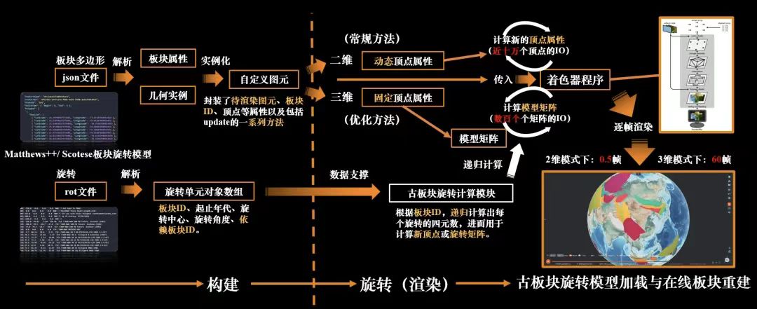
In response to the challenge of high-performance rendering of massive deep-time data,Our team continues to investigate visualization scenarios with performance bottlenecks.Developed geological plate reconstruction calculation and dynamic simulation technology.Deep-time plate rotation is a signature feature of EE, which can dynamically reconstruct the evolution of ancient plates from now to 540 million years ago through the form of dynamic rotation of the current distribution of land and sea on Earth.
In addition, we have also created a variety of functions, such as real-time dynamic simulation of millions of particle systems, custom rendering of millions of vector data, etc., which provide smooth and efficient visual simulation effects for deep time data and geological body data.
Visualization + development base support: significant application results achieved in two aspects
Use visualization analysis to inspire geoscientific problems and support geoscientific research
When scientists were studying the surface heat flow of the Qinghai-Tibet Plateau, EE loaded more than 10 geological and geophysical data sets, such as the Moho depth, into the Qinghai-Tibet Plateau region.The potential influencing factors of the surface heat flow distribution on the Qinghai-Tibet Plateau were visualized and analyzed in the form of plane + section.Further analysis of its distribution pattern inspired research ideas. Finally, scientists used spatial regression analysis to conduct research on the distribution of surface heat flow on the Qinghai-Tibet Plateau. The results have been published in the Journal of Geophysical Research-Solid Earth.
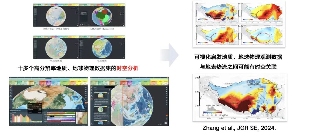
Comparative analysis of time and space of multi-source data inspires research ideas on surface heat flow in the Qinghai-Tibet Plateau
Create a plug-and-play development base and build customized subject work nodes
Geomorphology work has achieved rapid construction of discipline work nodes based on the EE development base.It displays high-precision, high-resolution datasets of more than 400 regions in geomorphology, supporting online visualization and download.Helped the Geomorphology Working Group to increase the international visibility of its research.The system supported the online release of the global ultra-high-resolution landform type map, which quickly received more than 8,000 visits and over 1,300 download applications.
In addition to the field of geomorphology,We also provide technical support in other disciplines.For example, in the mineral resources prediction discipline work platform, users can load relevant remote sensing data onto the three-dimensional earth, and then evaluate the inversion estimation results of remote sensing and field measurement data. Through the computing power of GPU/CPU, data-driven mineralization probability prediction is realized.
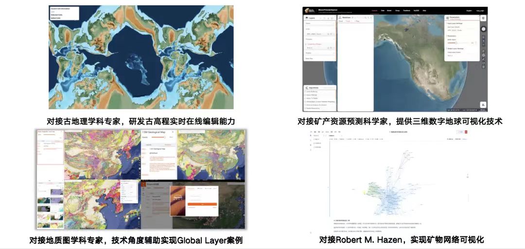
Supporting subject cases (paleogeography, mineral resources, mineral analysis, etc.)
With the support of the deep time plate rotation function,EE can rotate modern geological maps to 540 million years ago, and can also use public data sets to display the three-dimensional topography of Mars and the Moon, providing a virtual environment for scientists to study outer space planets.Next, our team plans to continue researching foreign closed-source geological software and strive to break the monopoly of foreign geological technology systems.
In summary, the Earth Explorer deep time visualization analysis system developed by Professor Du Zhenhong's team at Zhejiang University is an online geoscience professional visualization analysis system.EE realizes online multi-dimensional rendering and spatiotemporal dynamic analysis of geoscientific data,It not only solves the problem of visualization and simulation in deep-time earth science research, but also brings new inspiration and analysis methods to earth science research. In the future, with the continuous advancement of artificial intelligence and digital twin technology and in-depth cooperation with scientists, EE is expected to play a greater role in the field of earth science.
About Teacher Qi Jin
The guest speaker of this sharing session, Mr. Qi Jin, is from the School of Earth Sciences of Zhejiang University. His research interests include artificial intelligence oceanography and the development of geoscience big data analysis platforms. He has presided over a number of important scientific research projects, including the "14th Five-Year Plan" national key research and development program sub-projects and National Natural Science Foundation projects. He has served as the technical leader of the Zhejiang Coastal Ecological Environment Multi-source Information Intelligent Service Platform and won the first prize of the Marine Engineering Science and Technology Award.
Teacher Qi Jin's personal homepage:
https://person.zju.edu.cn/qijin