Command Palette
Search for a command to run...
A New Approach Combining Explicit Geological Constraints With data-driven Models Has Enabled a Team From Zhejiang University to Improve the Performance and Interpretability of cross-regional Mineral Prospect prediction.

In recent years, the deep integration of artificial intelligence and geoscientific data has significantly promoted the development of mineral resource prediction methods. Mineral Prospectivity Mapping (MPM) has become an important technical means to reduce mineral exploration risks and support resource exploration under deep and complex geological conditions. However, mineralization is controlled by multiple geological factors such as tectonics, lithology, and magmatic activity, and has significant spatial non-stationarity and directional characteristics.Most existing machine learning and graph model methods tend to handle these spatial features implicitly, making it difficult to explicitly characterize the anisotropy and regional differences in the mineralization process.Therefore, there are still shortcomings in terms of geological interpretability and predictive stability.
In response to the above problems,A research team from Zhejiang University has proposed a geologically constrained, data-driven mineralization prediction method.By explicitly introducing anisotropic spatial proximity relationships and spatial nonstationary modeling mechanisms into the prediction framework, a quantitative expression of the control over mineralization heterogeneity and directionality is achieved. This method constructs an anisotropic spatial proximity neural network and combines a convolutional attention weighting mechanism with a logistic regression model to effectively integrate multi-source geoscientific information.While maintaining prediction accuracy, it significantly enhances the geological consistency and interpretability of the model.
Multi-scale validation in the Megama terrane gold deposit in Canada and the Cordillera porphyry copper metallogenic belt in the United States shows that...This method outperforms many mainstream models in terms of recall and overall generalization performance, and can reveal key ore-controlling factors and mineralization directionality at the regional scale.This study provides a new technical approach for explicitly incorporating geological constraints into data-driven models and has reference value for intelligent mineral exploration and quantitative research on mineralization mechanisms.
The research findings have been published in Geology under the title "Geologically constrained data-driven modeling for mineral prospectivity mapping".
Research highlights:
* Breaking through the implicit processing limitations of traditional machine learning methods, this paper constructs an anisotropic spatial proximity neural network to achieve a quantitative characterization of the spatial heterogeneity of complex mineralization processes.
* The deep integration of geological constraints and data-driven methods maintains the interpretability of the model structure and geological consistency;
* It can reveal key ore-controlling factors and ore-forming directional characteristics at the regional scale, and achieve robust generalization performance for cross-regional and multi-scale verification.
Paper address:
https://go.hyper.ai/vbUpa
Follow our official WeChat account and reply "metallogenic prediction" in the background to get the full paper.
More AI frontier papers:
A robust prediction of mineralization probability is achieved based on a deep neural network weighted logistic regression model.
Mineralization is typically controlled by a combination of tectonic, lithological, magmatic, and geophysical-geochemical factors.Its spatial distribution exhibits significant non-stationarity and directional characteristics.This makes it difficult for traditional statistical models or purely data-driven methods that rely on global assumptions to accurately characterize mineralization differences and local mineralization patterns at the regional scale. Although machine learning and artificial intelligence methods have made significant progress in mineral prospect prediction in recent years, most models tend to handle spatial constraints implicitly, making it difficult to reflect the real geological control processes, thus still having shortcomings in terms of geological interpretability and generalization ability.
A research team from Zhejiang University systematically analyzed the limitations of existing mineral prospect prediction methods, focusing on the core scientific question of "how to explicitly introduce geological constraints in a data-driven framework." Traditional geostatistical methods can alleviate spatial nonstationarity to some extent, but their linear assumptions make it difficult to characterize complex nonlinear mineralization processes. While neural network and graph neural network methods, which have emerged in recent years, have shown outstanding performance in prediction accuracy,However, they often only learn spatial dependencies implicitly through model structure, lacking a direct characterization mechanism for mineralization anisotropy and spatial heterogeneity.These shortcomings limit the model's ability to identify regional tectonic control and mineralization directionality.
This study selected two representative regional-scale datasets:
* Dataset of the Meguma terrane goldfield in Canada:This area is a classic benchmark area in the field of mineral prospect prediction. It has complete mineral occurrence data and clear mineralization background, and has long been used for method comparison and performance evaluation.
* Dataset of the porphyry copper metallogenic belt in the southern Cordillera region of the United States:Covering multiple states, with large regional scales and complex tectonic and magmatic activities, it is used to test the stability and generalization ability of models in large-scale, complex geological environments.
These two datasets correspond to small-scale fine-grained prediction and large-scale regional generalization, respectively.The Canadian mining dataset was used as a benchmark for initial model evaluation and method comparison, to verify the model's recognition and recall performance in classic, small-scale gold mine prediction scenarios. The US mining dataset served as a generalization and validation area in large-scale, complex tectonic environments, to test the model's cross-regional stability and generalization ability in porphyry copper systems.
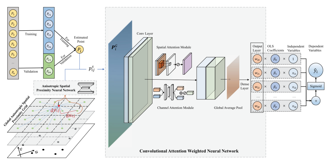
Based on data,This study proposes an anisotropic convolutional attention-weighted logistic regression (ACAWLR) model.This method is used for mineral prospect prediction under geological constraints. First, it extracts the primary and secondary mineralization directions of mineral deposit distribution through direction-weighted covariance analysis, and then constructs an anisotropic spatial distance metric based on this. Subsequently, it introduces an anisotropic spatial proximity neural network (ASPNN) to embed directional spatial relationships into the model in a learnable manner, thereby explicitly characterizing the direction-dependent features in the mineralization process.
Building upon this foundation, a convolutional attention weighted network is constructed by combining convolutional neural networks with spatial-channel attention mechanisms. This network learns spatially non-stationary ore-controlling weights and couples them with a logistic regression model to achieve robust predictions of ore-forming probabilities.
Multi-scale validation strategies and model comparison
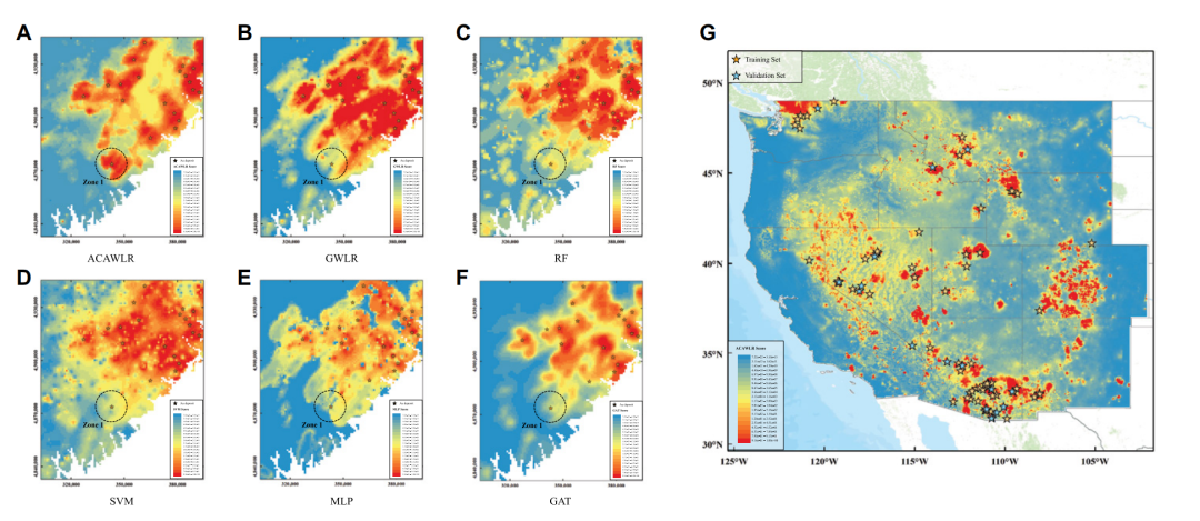
In terms of experimental design, the research team adopted a multi-scale, hierarchical verification strategy.First, a systematic comparative experiment was conducted in the Megama Terra in Nova Scotia, Canada, a classic benchmark area for gold deposit prediction.The proposed method is compared with several representative methods, such as geographically weighted logistic regression, support vector machine, random forest, multilayer perceptron, and graph attention network.
The results show thatACAWLR performed best in both recall and overall predictive performance.It achieves an effective balance between prediction accuracy, spatial generalization ability and geological interpretability, and can fully identify the distribution of known mineral deposits and generate more continuous and geologically consistent prospective maps.
Subsequently, the study further extended the method to the large-scale complex region of the western Cordillera porphyry copper metallogenic belt in the United States, verifying the stability and robustness of the model in cross-regional applications.
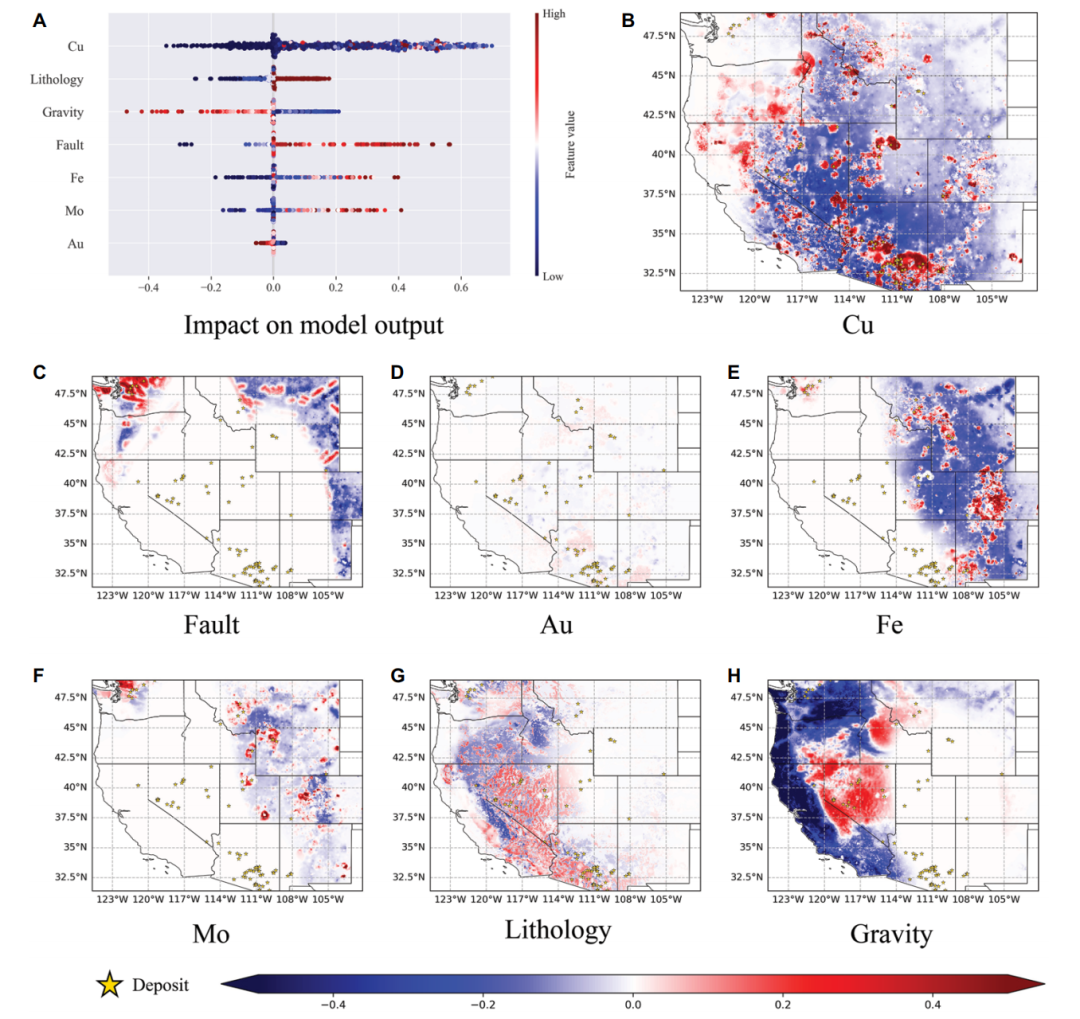
Furthermore, this study also conducted a large-scale mineralization interpretability analysis, systematically revealing the spatial differences in key ore-controlling factors across different regions. The results show that...Copper content plays a dominant role in porphyry copper systems, while factors such as lithology, faults, and gravity anomalies exhibit significantly different spatial influence patterns under different tectonic backgrounds.Through anisotropy analysis, the model further identifies the main metallogenic direction consistent with the regional tectonic system, providing an intuitive basis for understanding the metallogenic mechanism and guiding mineral exploration deployment.
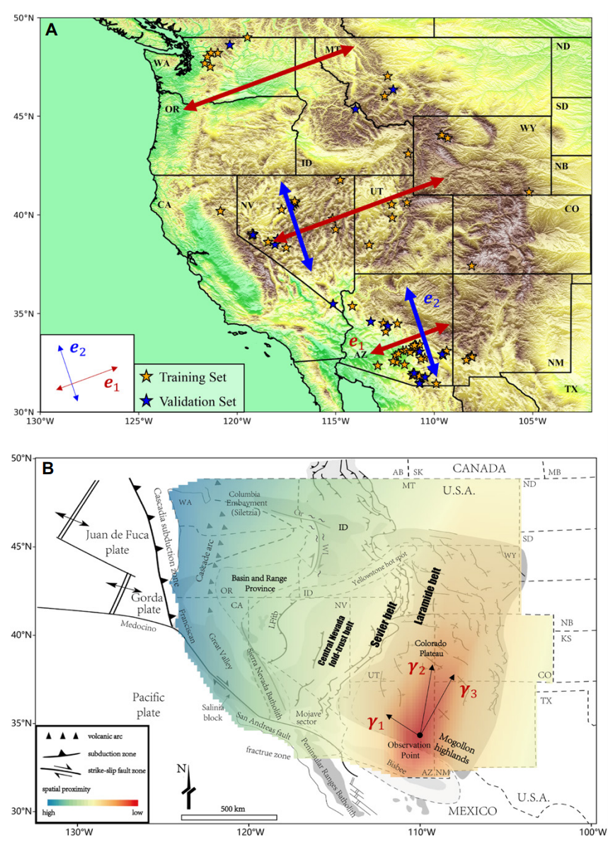
(A) Primary and secondary mineralization directions obtained from the eigenvalue decomposition of training samples of mineral deposits;
(B) Proximity distribution optimized by the Anisotropic Spatial Proximity Neural Network (ASPNN) (red indicates shorter, blue indicates longer). Background: distribution of magmatic arcs and tectonic zones from the Mesozoic to the present (according to Yonkee and Weil, 2015). Canada: AB—Alberta; MB—Manitoba; SK—Saskatchewan. United States: AZ—Arizona; CA—California; CO—Colorado; ID—Idaho; KS—Kansas; MT—Montana; ND—North Dakota; NB—Nebraska; NM—New Mexico; NV—Nevada; OR—Oregon; SD—South Dakota; TX—Texas; UT—Utah; WA—Washington; WY—Wyoming.
Regarding the team from the School of Earth Sciences, Zhejiang University
In recent years, the team from the College of Earth Sciences at Zhejiang University has achieved a series of cutting-edge and engineering-application-value research results in the interdisciplinary field of earth science and artificial intelligence.
The team's GNNWR series models have been used by industry professionals, with a cumulative total of nearly 50,000 downloads, calls, and citations.It has been widely applied in various fields such as oceanography, geography, atmospheric science, and geology. The results of this work have been published in the renowned Earth science journal *Geoscientific Model Development*, with the title "GNNWR: An Open-Source Package of Spatiotemporal Intelligent Regression Methods for Modeling Spatial and Temporal Non-Stationarity".
Paper address:https://gmd.copernicus.org/articles/17/8455/2024
Model open source address:https://github.com/zjuwss/gnnwr
February 2025The team proposed a deep learning model based on an attention mechanism—Contextual Attention-Driven Geographically Weighted Regression (CatGWR).By calculating contextual similarity between samples using an attention mechanism and combining it with spatial proximity, contextualized spatiotemporal weights are generated, thereby more accurately estimating spatial non-stationarity. The related findings, titled "Using an attention-based architecture to incorporate context similarity into spatial non-stationarity estimation," were published in the International Journal of Geographical Information Science.
Paper address:https://www.tandfonline.com/doi/full/10.1080/13658816.2025.2456556
Click to view the full interpretation:Taking the 1.7K Shenzhen residential housing price as an example, the Zhejiang University GIS Laboratory uses the attention mechanism to mine geographic context features and improve the accuracy of spatial non-stationary regression.
In November of the same year,The team also proposed a heterogeneous contrastive graph fusion network (HCGFN) for joint classification of HSI and LiDAR data, achieving efficient interaction and effective fusion between HSI and LiDAR.The findings of this work have been published in IEEE Transactions on Geoscience and Remote Sensing, a renowned journal in the field of Earth sciences, with the title "Aggregative and Contrastive Dual-View Graph Attention Network for Hyperspectral Image Classification".
Paper address:https://ieeexplore.ieee.org/document/11115095
The team also applied spatial intelligence models to socioeconomic geography problems, achieving significantly better fitting results than traditional models by introducing spatial proximity and deep learning structures. Their paper, titled "Spatial non-stationarity assessments of housing prices in Wuhan based on a TD-GNNWR model," was published in the *Acta Geographica Sinica*.The team developed a spatial distance metric and neural network fusion model based on travel time (TD) (TD-GNNWR), which significantly improves the fitting and interpretability of spatial non-stationarity of urban housing prices.
Paper address:https://www.geog.com.cn/CN/10.11821/dlxb202408005
Furthermore, the research team extended spatiotemporal intelligent regression and deep learning methods to the construction of geological, marine, ecological, and atmospheric environmental models.For example, spatially weighted neural networks can be used to accurately estimate the surface heat flow distribution of the Tibetan Plateau, providing key insights into the geodynamic processes within the Earth.The related research, titled "The Distribution of Surface Heat Flow on the Tibetan Plateau Revealed by Data‐Driven Methods," was published in the Journal of Geophysical Research: Solid Earth.
Paper address:https://doi.org/10.1029/2023JB028491