Command Palette
Search for a command to run...
Deep Learning Discovers Ancient Human Sites, AI Archaeology Is More Efficient Than Hu Bayi
Archaeology has always been a mysterious and attractive topic.
Hu Bayi, the protagonist of the tomb-robbing novel series "Ghost Blows Out the Light", relied on half of the "Sixteen-Character Yin-Yang Feng Shui Secret Technique" to master the art of seeking dragons and dividing gold to locate burial sites, and thus found large tombs and treasures.
Hu Bayi's formula:To find dragons and divide gold, look at the mountains that surround them. Each layer of entanglement is a barrier. If there are eight levels of danger, they will form the shape of Yin and Yang Bagua.Help him use the Bagua astrology to determine the location of the tomb, find the escape exit, successfully complete the task, and solve the problem.
In recent years, archaeological events have frequently been trending on the Internet. Common headlines in the news include:Aegean farmers unearthed ancient Greek sculptures, Xi'an Metro stopped construction for a Warring States tomb, etc., making archaeological work look very much like opening a blind box, as if discovering the relics depends on luck.
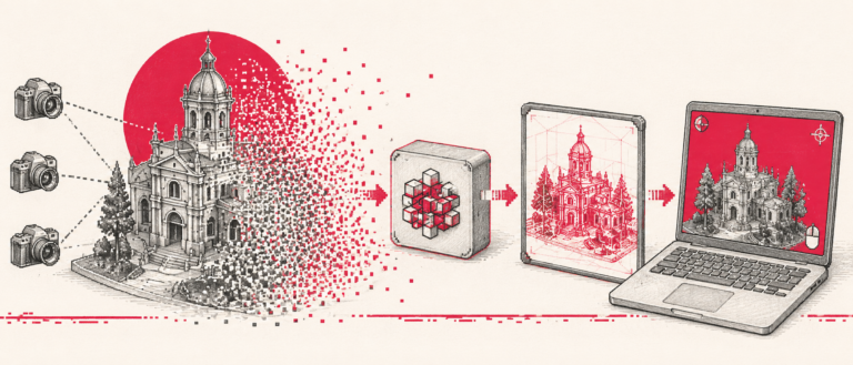
AI Archaeology: Deep Learning Has Great Potential
Dylan Davis, a Ph.D. in anthropology at the University of Illinois, is committed to incorporating remote sensing and deep learning into archaeology to bring more discoveries.
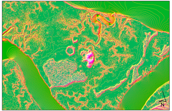
Based on LiDAR data from several areas in South Carolina, combined with local SAR synthetic aperture radar and multispectral data, and using machine learning and deep learning methods, he discovered several remains of Native American survival dating back 3,000 to 5,000 years.
The ancient humans' residences were often surrounded by piles of eaten shellfish, animal bones, and food residues, which over time formed a circular enclosure. In archaeology, such human sites are called shell mound sites or shell ring sites.
Such sites often appear in coastal areas and have been found in my country, Japan, Britain, North Africa and other parts of the world. These sites usually belong to the Neolithic period or as late as the Bronze Age.
The investigation of ancient human shell midden sites and the analysis of site sediments can provide rich research data for the development chronology, social formation, and climate and environmental changes of the indigenous peoples of North America.
When these ancient humans built their settlements, they made slight changes to the soil voids and topography, but after thousands of years of changes, these changes are difficult to observe on the ground with the naked eye, which makes the discovery of these sites more difficult.
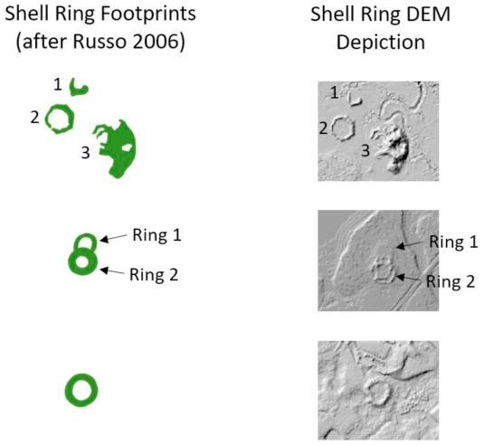
There are circles, interconnected circles, and semicircles
When using machine learning and deep learning for image processing, Dylan first downloaded the LiDAR data of the experimental area, extracted the digital elevation model (DEM) from it, analyzed it to obtain hillshade and slope, and rotated it 45° to enhance the training data.
Finally, we obtained 776 annular terrains, 720 shell mound terrains and 1316 irrelevant terrains, which were exported as 200*200 images, and 10% was retained as the validation set.
Dylan and his team designed a Mask-R-CNN model based on ResNet 50. In order to cross-validate the deep learning results of the model based on LiDAR training data, the team also performed a random forest (RF) probability analysis on the annular terrain of the study area based on the multi-temporal SAR data of Sentinel-1 and the multispectral data of Sentinel-2.
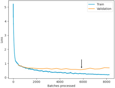
Dylan and his team worked on a workstation with an NVIDIA Quadro p4000 GPU, an Intel® Core™ i7-7700K CPU @ 4.20 GHz, 4200 Mhz, 4 cores, 8 logical processors, and 64 GB of memory.After training for more than 40 hours and running for 20 epochs, the training and validation losses of the best model were 0.252 and 0.554 respectively.
Prior to Dylan and his team's study, there were about 50 known ancient human sites in the Great Lakes region of the United States, where traces of human survival such as stone tools and pottery were found. Dylan's research results show that there are still nearly 100 suspected ancient human sites in these areas waiting to be verified.
Dylan mentioned in recent research that the next step is to conduct field research based on the training results.
Space Archaeology: Non-destructive Archaeological Research
Real archaeology is not as mysterious as dividing gold and locating tombs. There are no legendary treasure maps and mysterious keys. Most contemporary archaeological work is non-active excavation.
Due to the limitations of current excavation and protection methods, many cultural relics may be permanently damaged once they are excavated due to the lack of effective protection measures.For example, my country protects relics and archaeological discoveries with the standard of "no active excavation unless necessary", so space archaeology is receiving more and more attention.
After World War II, archaeological communities around the world began to use space technology, especially in combination with remote sensing, to conduct archaeological research.Remote sensing archaeology is mainly carried out by analyzing remote sensing images and combining them with archaeological results, history and documentary materials. It can not only avoid spending a lot of time, money and energy on field work, but also reduce labor intensity.
Accurately determine the location, shape, size, etc. of cultural relics without touching them.Ancient ditches, ancient river channels or large buildings that are now buried beneath the surface can sometimes be clearly reflected in information-rich remote sensing data.
In 2014, a research team from my country's Institute of Remote Sensing and Digital Earth conducted archaeological work on the ancient Great Wall in Xinjiang for three years.
Relying on the faint information of ancient ruins obtained by remote sensing, scientific researchers "restored" the ancient Great Wall of Xinjiang, changing the long-standing perception that "there is no Great Wall in Xinjiang", which excited the archaeological community.
The use of remote sensing technology can help us understand the relics more intuitively and vividly, deepen our understanding of the temporal and spatial distribution patterns of human cultural relics, understand the human-land relationship patterns and their evolution process in different environments and social development stages, and provide a scientific basis for interpreting relics and culture.
Combined with AI technologies such as machine learning and deep learning, the processing of space remote sensing data can be efficiently improved, further accelerating the exploration and protection of cultural relics.
In short, the technology of "tomb robbing" is good and fast.
References:
- "Deep learning reveals extent of Archaic Native American shell-ring building practices" Dylan S.Davis
- "Remote sensing archaeology "into the sky and into the earth" Space archaeology has great potential" Institute of Aerospace Information Innovation, Chinese Academy of Sciences
- "Application of Remote Sensing Technology in Archaeology" (http://blog.sina.com.cn/s/blog_5554ecf401000e45.html)