Command Palette
Search for a command to run...
What Can AI Do in the Face of Raging Forest Fires?
For the problem of forest fires that cannot be eliminated, AI technology combined with satellite imagery can provide timely and reasonable insights during the disaster relief process, helping people minimize losses.
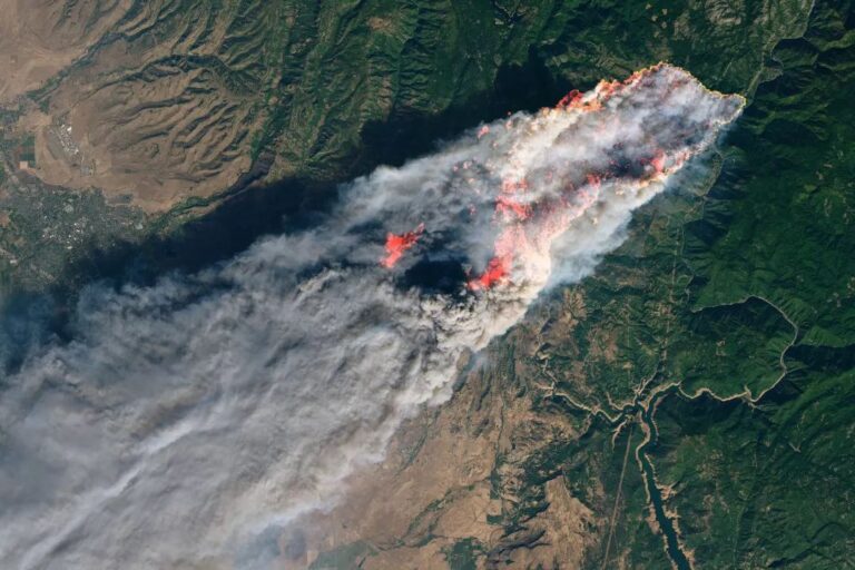
On April 4, the forest fire in Liangshan, Sichuan, claimed another life, bringing the total number of firefighters killed in this ruthless disaster to 31. This is a sad number.

There is no way to completely avoid forest fires, and we often hear about the huge losses caused by fires in reports. So is there any way to resist forest fires?
In disaster relief work, it is crucial to obtain comprehensive and accurate information in a timely manner to achieve the rational allocation of resources. Now, AI-based technology is playing a role, which can help us race against time and save more lives and losses.
Perhaps the next time we face a wildfire, AI can help us fight it.
AI technology at work in fires
During last year’s devastating California wildfires, a company called CrowdAI participated in the rescue effort using satellite data and integrated image vision technology.

CrowdAI uses satellite imagery from Spacenet and Deepglobe, as well as data from DigitalGlobe and Planet Labs, to train convolutional neural networks.
It only takes one second to predict and assess the extent of the disaster, and then report the assessment results to the rescue command center to help scientifically allocate rescue resources and formulate more scientific rescue plans.

With the help of CrowdAI's customized deep learning model, in addition to labeling conventional house buildings, it has also expanded to independent structures such as carports, utility sheds and barns.
In that fire, after identifying the structure from satellite imagery, the AI model marked the location of the damage with red dots based on a comparison of images before and after the disaster.

Expanding to the entire area, the severity of the disaster can be determined by the number of marked points, and different colors can be used to distinguish the degree of the disaster.
Finally, marking them on Google Earth or ArcGIS can provide guidance for disaster relief and reconstruction work.

Devaki Raj, founder and CEO of CrowdAI, said of the ongoing pursuit of speed in assessments, “When disaster strikes, we have to give predictions quickly, and that’s why we need this speed.”
Many rescue workers and government officials use this rapidly generated data to more rationally coordinate rescue efforts, which improves the efficiency of solving critical problems.
In order to complete the disaster assessment as accurately as possible, previous methods required a large amount of data training, but Jigar Doshi, head of machine learning at CrowdAI, mentioned that "because machine vision technology is already very mature, we don't need to train a large model (for disaster conditions) to conduct effective assessments."
Satellite data for humanistic care under the guidance of AI
CrowdAI uses satellite images and other technologies such as computer vision to provide data services. The slightly different thing is that they focus their energy mainly on natural disasters.
CrowdAI has also collaborated with Facebook AI to study the assessment of damage caused by hurricanes and fires. Their research results, "From Satellite Imagery to Disaster Insights", were also accepted by the NeurIPS conference.
(https://aiforsocialgood.github.io/2018/pdfs/track1/23_aisg_neurips2018.pdf)
In the paper, their research achieved strong results: it achieved 88.8% accuracy in identifying roads damaged by Hurricane Harvey near Texas in 2017, and 81.1% accuracy in identifying damaged buildings in the Santa Rosa fire.

In terms of disaster prediction, CrowdAI is also exploring predictive disaster models. It is said that they are trying to actively develop deep learning tools that can surpass satellite images by integrating data such as wind, precipitation and social media.
AI is on the rise in the fight against wildfires
In addition to CrowdAI, other companies and organizations are making similar efforts.
The Nature Conservancy is using small satellite images and AI technology to introduce forest firefighting tools. High-definition images taken by a large number of small satellites can monitor forest conditions in real time, and AI data analysis can be used to make timely prevention and warnings.
There is also a company called Salo Science, which is using AI technology to study forest fire risk assessment. The AI product they are developing is also based on satellite images and data. By analyzing the conditions of trees, terrain, topography, combustible materials and other factors, it provides firefighters with forest regional topographic maps and risk indicator data, helping them make better choices when danger comes.

In addition, research on firefighting robots has also been progressing. In a recent report, a firefighting robot in Xiaoshan performed well in a fire, rushing into the fire, exploring the way, and cooperating with firefighters to successfully put out the fire. However, firefighting robots are not smart enough to cope with complex terrains, and currently cannot carry out disaster relief alone.
Perhaps, in the near future, these applications combined with AI or robots will be able to tame terrible fires.
Google and McKinsey Global Institute have produced a report on cases where AI benefits humanity. The report states that “AI can provide more accurate rescue and emergency preparedness, is faster than human rescue, and has a wider range of applications.”
Looking forward to the day when AI can tame fire!