Command Palette
Search for a command to run...
WorldClaw: توليد وكيلي لعوالم ثلاثية الأبعاد مفتوحة على نطاق واسع
WorldClaw: توليد وكيلي لعوالم ثلاثية الأبعاد مفتوحة على نطاق واسع
Chunchao Guo Yang Li Jinpeng Li Zilong Huang
الملخص
لا يزال توليد عوالم ثلاثية الأبعاد واسعة النطاق وقابلة للاستكشاف بحرية انطلاقاً من نصوص مفتوحة أمراً صعباً، لأن النظام يجب أن يحافظ في آنٍ واحد على تماسك مكاني عالمي، ومحتوى محلي غني، وأصول صريحة مناسبة للتحرير وإعادة الاستخدام لاحقاً. نقدم WorldClaw، وهو إطار عمل وكيلي بالكامل، يعمل من الخشن إلى الدقيق، لتوليد مشاهد ثلاثية الأبعاد في عوالم مفتوحة. يقوم وكلاء التخطيط بترجمة موجه نصي إلى مواصفات هيكلية للمناطق، والتضاريس، والأصول، والمواد، والعلاقات المكانية. بعد ذلك، يبني WorldClaw أساساً تضاريسياً متماسكاً عالمياً انطلاقاً من التخطيطات الدلالية، والأصول القابلة لإعادة الاستخدام، والمواد التوليدية أو الإجرائية، وحقل ارتفاعات واعٍ بالمناطق. بالنسبة للمناطق التي تتطلب تفاصيل عالية، يقوم بتوليد تراكيب مشروطة بالتضاريس، وإعادة بناء شبكات مُزخرفة قابلة للتحرير، واستعادة مواضعها على التضاريس؛ ويقوم وكلاء قائمون على التصيير بتحسين التضاريس، والأجسام، والمظهر، ونقاط التلامس بشكل أكبر. عبر مجموعة متنوعة من المطالبات الخاصة بالعوالم المفتوحة، ينتج WorldClaw مشاهد واسعة النطاق ذات تنظيم مكاني متماسك، ومحتوى محلي جذاب بصرياً، وأصول قابلة للتحرير على مستوى النسخ، مع الحفاظ على بنية تضاريس عالمية متسقة.
One-sentence Summary
Tencent Hunyuan presents WorldClaw, a fully agentic, coarse-to-fine framework for large-scale open-world 3D generation that employs planning agents to convert text into structured region and asset specifications, constructs a globally coherent terrain foundation using region-aware height fields, and applies render-based refinement to produce editable instance-level assets and visually compelling local content.
Key Contributions
- WorldClaw is a fully agentic, coarse-to-fine framework that uses planning agents to translate text prompts into structured specifications of regions, terrain, assets, and materials for open-world 3D scene generation.
- It builds a globally coherent terrain foundation from semantic layouts and a region-aware height field, generates terrain-conditioned compositions with editable textured meshes, and uses render-based agents to refine contacts and appearance.
- The framework constructs terrain materials as executable Blender material-node graphs and shader scripts, achieving visually compelling results that remain explicitly parameterized and editable.
Introduction
Generating freely explorable 3D worlds from open-ended text is critical for video games, virtual reality, embodied simulation, and film, where scenes must maintain coherent geometry, appearance, and semantics for walkable, persistent environments. Prior work spans procedural generation (limited by rigid rules and content diversity), image‑ or video‑lifting approaches (often producing geometrically inconsistent, computationally heavy results), native 3D diffusion (constrained by scarce large‑scale scene datasets), and multimodal LLM agents (lacking precise 3D spatial control). The authors address these gaps by introducing WorldClaw, a coarse‑to‑fine agentic framework that first establishes a global semantic terrain foundation, then selectively populates regions with generated 3D objects, and finally applies render‑based agentic refinement to improve quality, scale, and object‑terrain contact, yielding editable, globally coherent 3D worlds from a single prompt.
Method
Given an open-ended user prompt q, WorldClaw aims to construct an explicit 3D world S whose global organization, terrain geometry, surface appearance, and object composition are consistent with the user intent. Rather than synthesizing the entire world in a single pass, the authors adopt a coarse-to-fine, global-to-regional construction strategy. The construction process consists of three sequential stages:
P=Fplan(q),T=Fterrain(P),O=Fregion(P,T),where P denotes the structured scene specification, T denotes the global terrain representation, and O denotes the set of generated and placed regional object instances. The final world is composed as S=Compose(T,O).
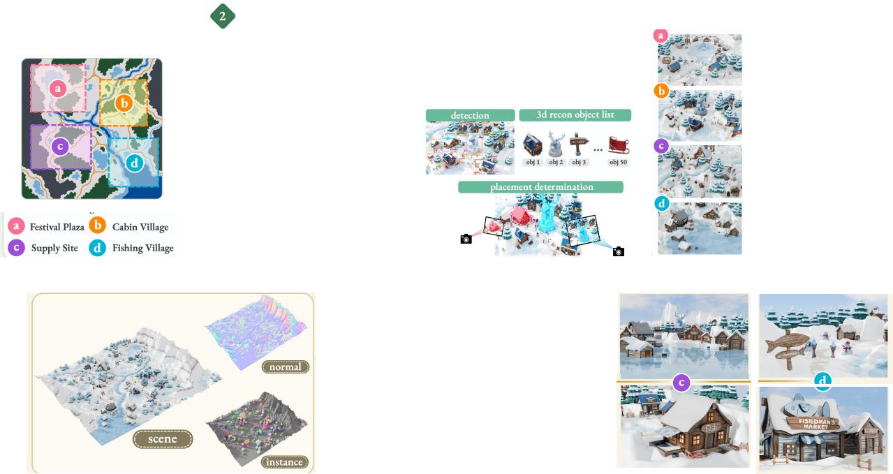
The intent analysis and planning stage converts the open-ended user prompt into a structured scene specification P. This module comprises an intent analysis agent and a scene planning agent. The intent analysis agent extracts and normalizes explicit constraints from the prompt, including scene type, theme, visual style, key regions, objects, and spatial relationships. Conditioned on these constraints, the scene planning agent resolves ambiguous descriptions and completes unspecified information according to a predefined schema. The resulting scene plan is organized as P=(R,Cterrain,Cobject), where R describes major scene regions and their spatial relationships, Cterrain describes terrain types and surface appearance, and Cobject specifies object categories and densities. This specification serves as a shared semantic interface for subsequent modules.
The global terrain generation module transforms the structured scene specification P into a global terrain representation T. It comprises three sub-stages: terrain planning, terrain asset generation, and terrain generation and refinement. The terrain planning agent converts terrain-related constraints into a structured terrain specification Pterrain=(playout,passet,pmaterial,θterrain), detailing region categories, asset densities, surface types, and numerical parameters like world scale and noise frequencies. When textual constraints are insufficient, the agent generates a scene concept image Iconcept as visual conditioning.
The terrain asset generation agent takes Pterrain and Iconcept to produce an intermediate asset package Aterrain=(Ilayout,Iasset,Oasset,Mterrain). This includes a global semantic layout map Ilayout encoding region categories, reusable 3D asset prototypes Oasset generated via image-to-3D conversion, and surface materials Mterrain constructed through generative texture synthesis and procedural material generation.
Finally, the terrain generation agent constructs the global terrain representation T.

The initial height-field generation parses the layout map to extract region masks and computes a composite height field:
H(x)=r∑mr(x)[hr+k∑wr,kNr,k(x)+j∑αr,jGr,j(x)],where hr is the base elevation, Nr,k represents noise components, and Gr,j denotes geomorphic operators. Following this, global terrain asset scattering instantiates reusable prototypes based on regional semantics and local surface conditions. A terrain refinement agent then iteratively re-renders and inspects the scene to correct geometric transitions, material scales, and asset distributions.
To populate selected regions while preserving the global terrain structure, the authors introduce a regional object generation and placement module. The regional planning agent jointly examines P and T to select a subset of regions R+ for further development, refining scene-level constraints into a regional specification Pregional.
The object generation and placement stage decomposes into region composition, object generation, and object placement. For each region, the agent renders the existing terrain to produce a terrain image Irterrain and generates a region composition image Ircomp conditioned on the terrain rendering and regional specification. Text-guided segmentation extracts individual 2D object instances, which are then reconstructed into 3D meshes Mi using single-view reconstruction. Image-space scale calibration ensures consistent sizing. Object placement recovers 3D positioning by intersecting rays from the object reconstruction camera and the regional terrain camera, computing the placement transformation Tplacei to align objects with the terrain surface.
Although the preceding stages provide independent object meshes and initial placements, a regional scene may still contain inconsistent scales, insufficient geometry quality, or object-terrain contact defects. The authors introduce a scene refinement agent that connects to a 3D engine through an executable interface.

The agent maintains a task queue and performs object refinement followed by terrain refinement. For object refinement, the agent evaluates pose, mesh quality, and scale. Objects with inconsistent properties are corrected, and reconstructions with insufficient quality are further refined by conditioning a 3D generator on the coarse mesh and object-centric image to improve local surface geometry and textures. For terrain refinement, the agent evaluates terrain-surface quality and object-terrain collisions. When defects like floating or excessive penetration are detected, the agent performs object-terrain co-deformation within the local support region, repositioning objects or locally displacing the terrain to conform to the object footprint. This loop continues until the scene passes diagnostic checks.
Experiment
The evaluation tests WorldClaw across diverse open-world prompts (tropical island, canyon, desert battlefield, snow-covered mountain valley) using an agent architecture built on Claude Opus 4.8 with integrated foundation models for scene construction, refinement, and rendering. Qualitative results demonstrate that the method generates globally coherent terrains with pronounced elevation variation and region-specific content while maintaining plausible object scales and terrain contacts, and the explicit representation keeps terrain and objects as independently manageable meshes. In comparisons with SynCity, Marble, MajutsuCity, WorldGen, and GPT-5.6 Sol, WorldClaw produces more expressive landforms, richer and better-aligned scene elements, and stable free-viewpoint appearance with instance-level editability, whereas baselines exhibit weaker long-range organization, limited content diversity, or degraded geometry over extended views.