Command Palette
Search for a command to run...
Hadoop-GIS: A High Performance Spatial Data Warehousing System over MapReduce
Hadoop-GIS: A High Performance Spatial Data Warehousing System over MapReduce
Ablimit Aji Fusheng Wang Hoang Vo Rubao Lee Qiaoling Liu Xiaodong Zhang Joel Saltz
Abstract
Support of high performance queries on large volumes of spatial data becomes increasingly important in many application domains, including geospatial problems in numerous fields, location based services, and emerging scientific applications that are increasingly dataand compute-intensive. The emergence of massive scale spatial data is due to the proliferation of cost effective and ubiquitous positioning technologies, development of high resolution imaging technologies, and contribution from a large number of community users. There are two major challenges for managing and querying massive spatial data to support spatial queries: the explosion of spatial data, and the high computational complexity of spatial queries. In this paper, we present Hadoop-GIS – a scalable and high performance spatial data warehousing system for running large scale spatial queries on Hadoop. Hadoop-GIS supports multiple types of spatial queries on MapReduce through spatial partitioning, customizable spatial query engine RESQUE, implicit parallel spatial query execution on MapReduce, and effective methods for amending query results through handling boundary objects. Hadoop-GIS utilizes global partition indexing and customizable on demand local spatial indexing to achieve efficient query processing. Hadoop-GIS is integrated into Hive to support declarative spatial queries with an integrated architecture. Our experiments have demonstrated the high efficiency of Hadoop-GIS on query response and high scalability to run on commodity clusters. Our comparative experiments have showed that performance of Hadoop-GIS is on par with parallel SDBMS and outperforms SDBMS for compute-intensive queries. Hadoop-GIS is available as a set of library for processing spatial queries, and as an integrated software package in Hive.
One-sentence Summary
Researchers from Emory University and The Ohio State University propose Hadoop-GIS, a scalable spatial data warehousing system on Hadoop/MapReduce that combines global partition indexing, customizable on-demand local spatial indexing, and the RESQUE query engine with boundary-object handling to efficiently execute large-scale spatial queries, achieving performance on par with parallel spatial DBMS and outperforming it on compute-intensive workloads while integrating declarative spatial querying into Hive.
Key Contributions
- Hadoop-GIS is a Hadoop-based spatial data warehousing system that supports multiple types of large-scale spatial queries through spatial partitioning, implicit parallel MapReduce execution, and handling of boundary objects to generate correct query results. The system targets massive spatial data on commodity clusters.
- Efficient query processing is achieved by combining global partition indexing, customizable on-demand local spatial indexing, and the RESQUE spatial query engine within MapReduce. This multi-level indexing and engine design supports multiple spatial query types.
- Hadoop-GIS is integrated into Hive to support declarative spatial queries with an integrated architecture. Experiments on two real-world use cases show efficient query response, high scalability, performance on par with parallel SDBMS, and better performance for compute-intensive queries.
Introduction
Ubiquitous positioning sensors, community mapping platforms, and scientific imaging tools now generate massive spatial data, and these datasets matter because spatial analytics can drive location-aware services, social science studies, and digital pathology workflows. Previous systems fall short at this scale: traditional parallel spatial databases are expensive, hard to tune, and slow to load millions of complex objects, while general MapReduce platforms have weak spatial query support and suffer from skewed data partitioning and incorrect results for boundary crossing objects. The authors leverage MapReduce and Hive to introduce a spatial data warehousing system that combines spatial partitioning, index-driven query execution, boundary object handling, and an extended declarative query interface. The authors' main contribution is a scalable and cost effective architecture for expressive analytical spatial queries, including point, containment, join, cross matching, nearest neighbor, and feature-based queries.
Dataset
-
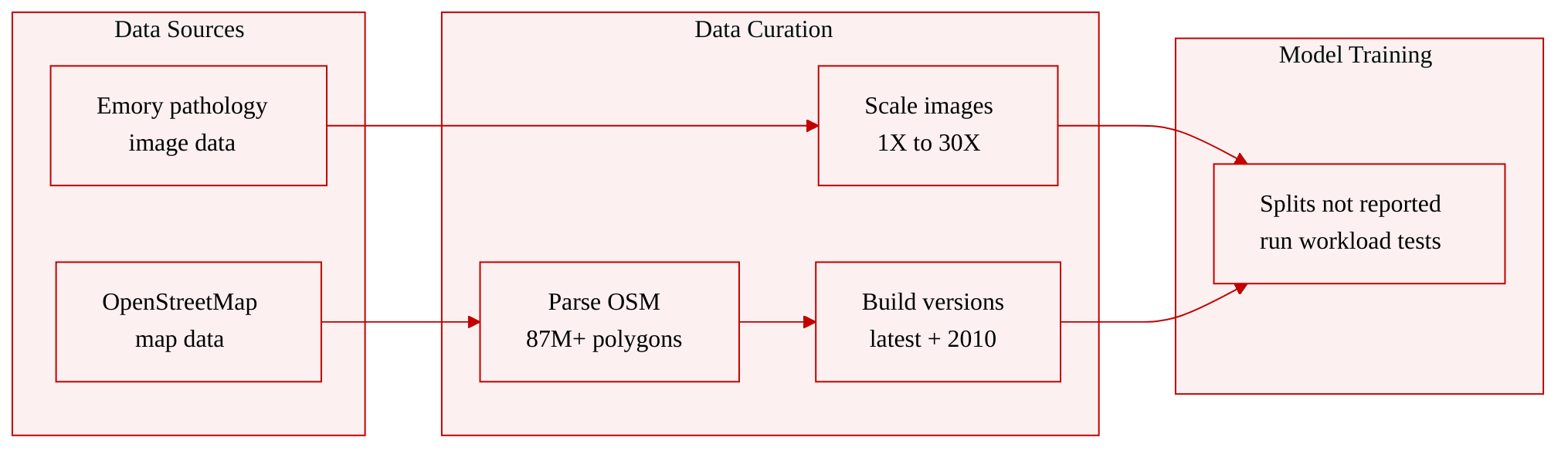
The paper evaluates performance using two real-world datasets: a pathology imaging dataset and an OpenStreetMap dataset.
-
Pathology Imaging dataset:
- Source: pathology images provided by Emory University Hospital.
- Data type: histopathology images used for analyzing and segmenting micro-anatomic objects such as nuclei and tumor regions.
- Spatial annotations: object boundaries are validated, normalized, and stored in Well-Known Text format.
- Scale variants: the authors prepare datasets at 1X, 3X, 5X, 10X, and 30X scale for different test scenarios.
- Size details: 1X contains 18 images and 44 GB, 3X contains 54 images and 132 GB, 5X contains 90 images and 220 GB, 10X contains 180 images and 440 GB, and 30X contains 540 images and 1,320 GB.
- Feature schema: each image contains an average of 0.5 million nuclei, and 74 features are derived for each nucleus.
- Usage: the dataset is used to test pathology-oriented spatial analysis and query workloads at different dataset scales.
-
OpenStreetMap dataset:
- Source: the official OpenStreetMap website, a large collaborative map project.
- Data type: spatial representations of geographic features such as lakes, forests, buildings, and roads.
- Geometry types: spatial objects are represented as points, lines, and polygons.
- Processing: the authors download the data and parse it into a spatial database.
- Schema: the table schema is simple and contains roughly 70 columns.
- Main table: experiments use the polygonal representation table, which contains more than 87 million records.
- Dataset versions: two versions are constructed for query testing, one based on the latest available version and a smaller version from an earlier release in 2010.
- Format for processing: the dataset is also exported as text for use with Hadoop-GIS.
-
Dataset construction and filtering:
- For pathology imaging, the dataset size is adjusted through predefined scale variants rather than described as a filtering process.
- For OpenStreetMap, the main filtering step is selecting the polygonal feature table for experiments.
- The authors create a latest-version dataset and a smaller 2010 dataset to support different query workloads.
- No explicit cropping strategy is reported for either dataset.
Method
The authors leverage a spatially partitioned, tile-centric execution framework to make large and computationally expensive spatial workloads practical on commodity clusters running Hadoop and HDFS. The system is designed around a simple principle: convert irregular spatial data into bounded processing units called tiles, execute query logic independently on those tiles, and then repair only the limited set of cases where parallel tile execution produces duplicate or boundary-sensitive results. This approach avoids the need to port a full spatial relational database engine into a distributed batch environment, while still supporting expressive spatial operations such as spatial joins, containment queries, range filtering, and geometry-based measurement.
Refer to the framework diagram.
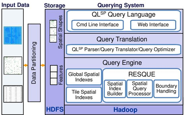
The architecture shown in the framework diagram is organized into three broad layers: input data preparation and partitioning, storage on HDFS, and the querying subsystem. The querying subsystem includes the spatial query language layer, query translation and optimization, and the query engine. A key component inside the query engine is the Real-Time Spatial Query Engine, known as RESQUE, which provides spatial index construction, spatial query processing, and boundary handling. The system exposes an extended SQL-like language, which can be written as QLSP, and a Hive-integrated spatial query layer written as HiveSP. Spatial data is first partitioned into tiles, then assigned tile identifiers, merged into large HDFS files, and indexed at multiple levels so that queries can operate efficiently on a tile-by-tile basis.
The overall query pipeline follows a sequence of stages. First, the system performs spatial partitioning to create tiles. Next, spatial objects are assigned tile UIDs and merged into HDFS-compatible files. Before execution, the system may perform query preprocessing, such as global index-based filtering to reduce the number of tiles that need to be scanned. The main spatial query processing then runs independently over tiles in parallel through MapReduce. If necessary, the system applies boundary handling as another MapReduce stage. Post-processing may join spatial results with non-spatial feature tables or aggregate attributes, and the final results are written back to HDFS.
A central design decision is how to partition the spatial domain. The authors focus on recursive partitioning rather than a simple fixed grid. Fixed grids can create severe load imbalance when spatial data is highly skewed. For example, one tile may contain thousands or even millions of objects while neighboring tiles contain only a few. In MapReduce, such a skew causes a straggler task to dominate the runtime. To mitigate this, each tile is evaluated against a threshold Cmax, which represents the maximum desired number of objects in a tile. Let n(t) denote the number of objects assigned to tile t. If a tile exceeds the threshold, it is split into two half-sized tiles along either the x or y direction. The split direction is chosen to produce a tile whose object count falls below the threshold, or to produce two more balanced child tiles.
n(t)>Cmax⇒t→{t1,t2},n(t1)≤Cmax, n(t2)≤Cmax.This procedure is repeated recursively until all tiles satisfy the target size bound. After partitioning, every spatial object receives the UID of the tile to which it belongs, although boundary objects may receive multiple tile assignments, as discussed later. The minimum bounding rectangles of tiles are stored in a global spatial index so that the system can quickly determine which tiles may be relevant for a query range.
For storage, the authors merge tiles into larger HDFS files rather than storing each tile as a separate file. This choice matters because HDFS is optimized for large blocks and for batch processing. A very large number of small files can hurt performance by increasing metadata overhead and by generating too many small map tasks during execution. Therefore, the system treats the tile set as a logical partitioning structure while physically packing multiple tiles into larger files suitable for HDFS.
The query engine architecture relies on two complementary indexing strategies. At the higher level, the system maintains global region-based indexes over tile MBRs. These indexes are small because they describe large granular regions rather than individual spatial objects. They can be stored in a compact binary format on HDFS and shared across nodes through the Hadoop distributed cache. For window, point, or containment queries, the global tile index can quickly identify the candidate tiles whose spatial extents intersect the query range, allowing the system to skip irrelevant tiles before more expensive computation begins.
At the tile level, the system uses on-demand spatial indexes. Instead of storing large permanent spatial indexes for every tile, RESQUE builds tile-local indexes during query execution when they are needed. The tile size is intentionally kept modest, so building an index over a single tile is fast. The index is kept in main memory, and in rare cases where memory is limited, secondary storage can be used. This design addresses a practical mismatch between HDFS-oriented storage and traditional spatial index engines: HDFS favors large sequential blocks, while spatial indexes usually require efficient random access at a much smaller granularity. By building indexes per tile in memory, the system avoids this mismatch and keeps query execution efficient.
RESQUE supports multiple access methods and geometry operations. It uses bulk-loaded R*-Trees for general spatial indexing, while Hilbert R-Trees can be used when objects are regular in shape and relatively homogeneous in distribution. The engine also supports spatial relationship predicates and measurement functions. For a spatial join, the system can test whether polygons intersect, compute their intersection area, compute the union area, derive an overlap ratio such as area(A∪B)area(A∩B), and compute centroid distances.
As shown in the figure below:
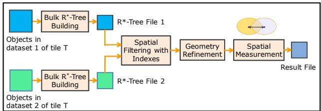
The spatial join workflow in RESQUE illustrates a filter-and-refine pattern. Consider two object datasets stored within the same tile T. The engine first performs bulk R*-Tree building on each dataset. The R*-Tree interior nodes store MBRs, while leaf nodes store polygon objects or their compressed representations. The engine then performs MBR-based spatial join filtering, which quickly produces candidate pairs whose bounding boxes intersect. Candidate pairs then pass through geometry refinement, where precise polygon intersection checks are performed. Finally, spatial measurement computes required query outputs, such as overlap ratio, centroid distance, or other derived geometry metrics. This layered workflow is important because bounding-box filtering can eliminate many false positives before the more expensive exact geometry calculations are performed.
Index optimization is applied because the data being queried is largely read-only. The system uses bulk-loading techniques and sets the page utilization ratio to 100% to reduce the number of pages. The system also compresses geometry payloads in leaf nodes. Instead of storing every x,y coordinate in full form, the system can encode coordinates using offsets from neighboring points, a compact chain-code representation. This reduces the memory and I/O cost of leaf-node storage, which is especially valuable for dense shape datasets.
The MapReduce integration is intentionally simple and implicit. The authors do not try to implement a fully distributed spatial query planner with explicit spatial task scheduling. Instead, they map spatial queries onto ordinary MapReduce stages. Because the data is already partitioned into tiles, the tile UID becomes the natural key for grouping. In the map phase, the system scans input records, evaluates local filters, and emits intermediate key-value pairs. The intermediate key is the tile UID, and the value contains the required columns plus a source tag that identifies which input table the record came from. For self-join queries, a shared scan can process both sides of the join in the same map pass, producing zero, one, or two intermediate records depending on the filter condition.
During the shuffle phase, Hadoop groups records with the same tile UID. In the reduce phase, the system receives all records belonging to one tile. The reduce function then separates records by source table and invokes RESQUE to build the necessary tile-local indexes and execute the spatial query. The output is serialized and written to HDFS. This structure supports spatial join by treating each tile as a small local join problem: the expensive geometry computation is performed independently inside each reducer.
Containment and selection queries can follow a more lightweight pattern. For these queries, the system can use the global tile index to identify tiles intersecting the query region. A map-only MapReduce program can scan only the relevant file splits, and the engine can filter candidate objects before applying precise geometric containment checks. For a small query region contained within a single tile, the workflow degenerates to a local index query inside that tile. For a point query, the system identifies the relevant tile and returns the objects that geometrically contain the point.
Boundary handling is one of the most important correctness mechanisms in the architecture. A spatial object that crosses a tile boundary cannot be processed correctly by a purely tile-local model unless special care is taken. For example, an object may extend across two neighboring tiles. If each tile is processed independently, the object may be lost, duplicated, or cause inconsistent join results. The authors use multiple assignment for boundary objects. During preprocessing, an object that crosses a tile boundary is duplicated and assigned to every tile it intersects. The duplicated copies are then processed like normal objects in their respective tiles.
As shown in the illustration below:
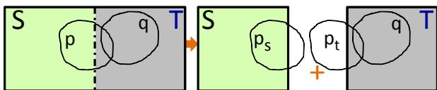
In the boundary-handling mechanism, a boundary object p crossing tiles S and T is represented as two copies, ps and pt. Each tile can then execute its query logic independently. If the query is a spatial join, tile-local processing may produce duplicate result pairs involving the replicated object. To correct this, the system runs a post-processing stage that normalizes the result set. Since each original object has a globally unique internal UID, the system can eliminate duplicate records by comparing object UIDs or result-pair identifiers. This post-processing can itself be implemented as a MapReduce job with relatively low overhead. The authors note that boundary objects usually represent only a small fraction of the dataset, so the extra replication and deduplication cost remains manageable.
The system also integrates with Hive to provide a declarative spatial query interface. This is important because analysts and application developers can express spatial workloads in SQL-like syntax rather than writing MapReduce programs directly. The Hive-based system extends HiveQL with spatial operators, spatial functions, and spatial data types. Users can define table schemas, specify spatial columns, and indicate spatial partitioning columns. Data is loaded through the normal Hive data-loading path, while the spatial partitioning metadata guides placement and pruning.
As shown in the figure below:
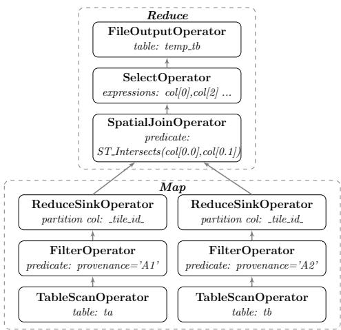
The query-processing path follows a plan-first, execute-next model. A SQL query is parsed into an abstract syntax tree, translated into a logical operator tree, and then optimized into a physical plan made of MapReduce tasks. When a query contains spatial operators, the logical plan is rewritten so that spatial operations map to internal spatial-engine operators. The system also inserts serialization and deserialization steps around spatial operators so that the Hive execution layer can pass data to and from the C++ spatial query engine. For a two-way spatial join, the resulting plan uses table scans on the input relations, filters that identify which input side a record belongs to, reduce-sink operators that partition records by tile identifier, and a reduce-side spatial join operator. The selection operator and output operator then project and write the final result.
In the physical plan, spatial data is partitioned by tile. This allows the reduce stage to evaluate spatial relationships locally and in parallel. Spatial predicates such as intersection, overlap, contains, and distance are executed inside RESQUE, while Hive continues to handle the surrounding relational operations. The optimizer can apply rule-based strategies such as predicate pushdown, column pruning, and index-aware filtering. For example, before launching expensive tile-level geometry computations, the system can use the global tile index to remove tiles that cannot contain matching objects.
The software design also emphasizes deployability. The spatial query engine is compiled as a shared library and deployed on cluster nodes. This allows the engine to be invoked from MapReduce tasks without requiring each task to depend on a heavyweight relational database process. The library-based design supports index construction, two-way and multi-way spatial joins, nearest-neighbor processing, and spatial measurement operations. Because the engine is separated from the distributed execution layer, spatial computation can be developed, optimized, and tested independently from Hadoop job coordination, while the MapReduce runtime provides scalability through its scheduler, shuffle mechanism, and distributed filesystem.
Experiment
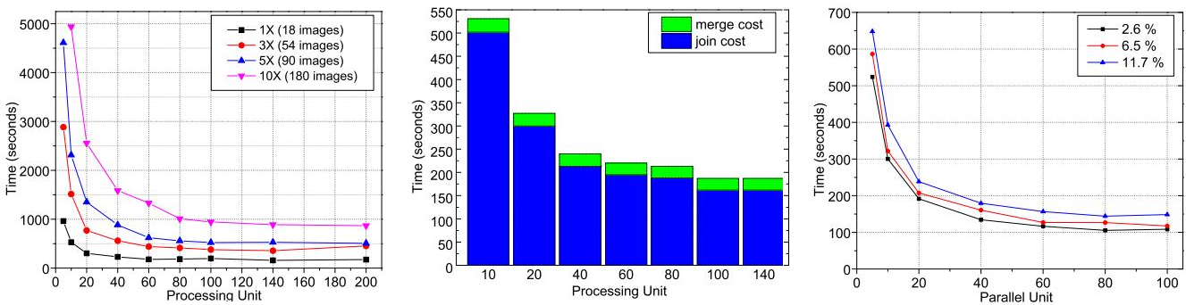
The experiments evaluate Hadoop-GIS on Hadoop, a tuned parallel spatial database, and PostGIS using real pathology imaging and OpenStreetMap datasets, with benchmarks for spatial join, containment, and aggregation, plus scalability and boundary-handling tests. The results show that the RESQUE engine is efficient for spatial joins and has low loading overhead, while Hadoop-GIS scales nearly linearly with more processing units and larger datasets and performs strongly on compute-intensive joins. The parallel database can be stronger for IO-oriented containment and aggregation tasks, and boundary handling adds only small practical overhead despite increasing with the fraction of boundary objects.