Command Palette
Search for a command to run...
Data-Driven Fire-Zone Segmentation for Improved Short-Term Wildfire Prediction
Data-Driven Fire-Zone Segmentation for Improved Short-Term Wildfire Prediction
Nicolas Caron Hassan Noura Christophe Guyeux Benjamin Aynes
Abstract
Wildfire prediction models typically discretize study areas into uniform grids, ignoring the heterogeneous spatial distribution of ignitions. We challenge this paradigm by showing that how data is discretized matters more than which model is used. We propose an unsupervised fire-zone segmentation algorithm combining watershed detection with K-means clustering to define prediction units directly from historical fire patterns. Experiments across six French departments and six forecasting models show that fire-zone segmentation consistently outperforms grid-based approaches, with mean IoU improvements of +3–6% depending on spatial scale. The method is computationally lightweight (<10s per configuration) and fully parallelizable. Our results demonstrate that optimizing spatial discretiza tion yields significant, reproducible performance gains for short-term wildfire forecasting. Supplementary materials are available here, and code will be released on GitHub.
One-sentence Summary
Researchers from Université Maris et Louis Pasteur, FEMTO-ST, and SAD Marketing propose an unsupervised fire-zone segmentation algorithm that combines watershed detection with K-means clustering to define prediction units from historical fire patterns, outperforming grid-based discretization with mean IoU improvements of 3−−6% depending on spatial scale for short-term wildfire forecasting.
Key Contributions
- An unsupervised fire-zone segmentation algorithm combines watershed detection and K-means clustering to define prediction units directly from historical fire distributions, requiring no labeled segmentation data.
- Across six French departments, six forecasting models, and multiple spatial scales, this data-driven segmentation consistently outperforms conventional grid-based approaches, with mean IoU improvements of 3–6%.
- The method runs in under 10 seconds per configuration, is fully parallelizable, and integrates seamlessly into existing short-term wildfire prediction pipelines.
Introduction
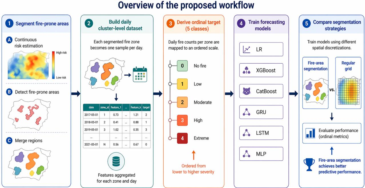
Wildfires impose a heavy economic and humanitarian toll, and early warning systems that fuse IoT sensors with AI offer a promising way to improve detection and resource allocation. However, the predictive performance of such AI models depends fundamentally on how the landscape is partitioned into prediction units. Most prior work relies on uniform grids, which dilute the ignition signal, introduce spatial noise from irrelevant features like water bodies, and suffer from severe class imbalance due to the overwhelming number of fire-free cells. These grid-based approaches also lose aggregated information and become unreliable at fine resolutions. While supervised deep learning methods have been applied to fire segmentation, they target post-ignition mapping rather than the preprocessing step of defining forecast zones before fires occur. The authors tackle this gap by proposing an unsupervised fire-zone segmentation algorithm that combines watershed detection with clustering to derive prediction units directly from historical ignition distributions. This data-driven preprocessing step consistently improves forecast accuracy over conventional grid-based methods without requiring any labeled segmentation data.
Dataset
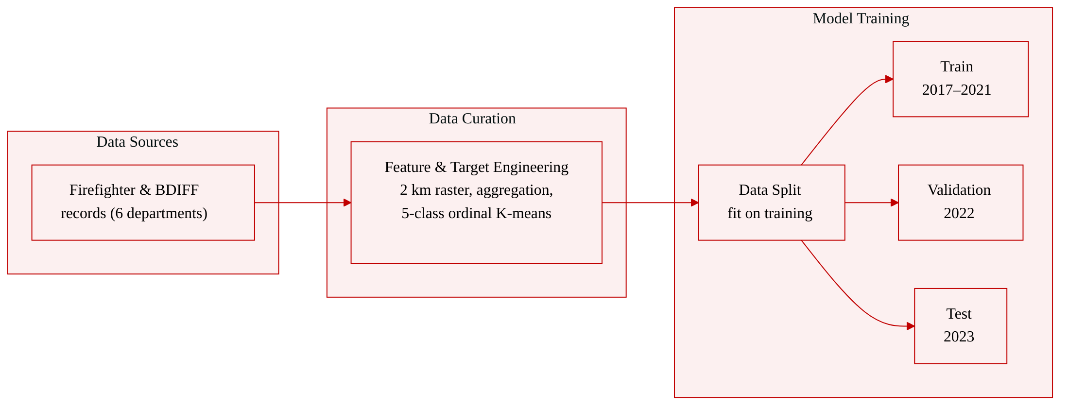
The authors evaluate their method on two wildfire datasets, both organized by French administrative departments.
Dataset composition and sources
- Firefighter interventions dataset: Compiled from firefighter records across four departments—Ain, Doubs, Rhône, and Yvelines—covering 2017–2024 (Rhône ends in 2022). The recorded location is the reporting position, not the exact fire origin, so spatial precision is limited. Most fires are human-caused.
- BDIFF (Forest Fire database): Centralized French forest fire records since 2006. The study uses data from Bouches-du-Rhône and Hérault (2017–2023), where fires are recorded at municipality level. This database captures only forest fires, not other wildland fire types.
Both datasets are used to validate spatial discretization because fire locations are imprecise and heterogeneous.
Target and feature construction
- The forecasting task is an ordinal multi-class problem. For each department, days with no fires are assigned class 0; days with fires are grouped by K‑means into four ordered categories—Normal, Medium, High, Extreme—based on daily fire counts. This emphasizes typical fire-activity patterns.
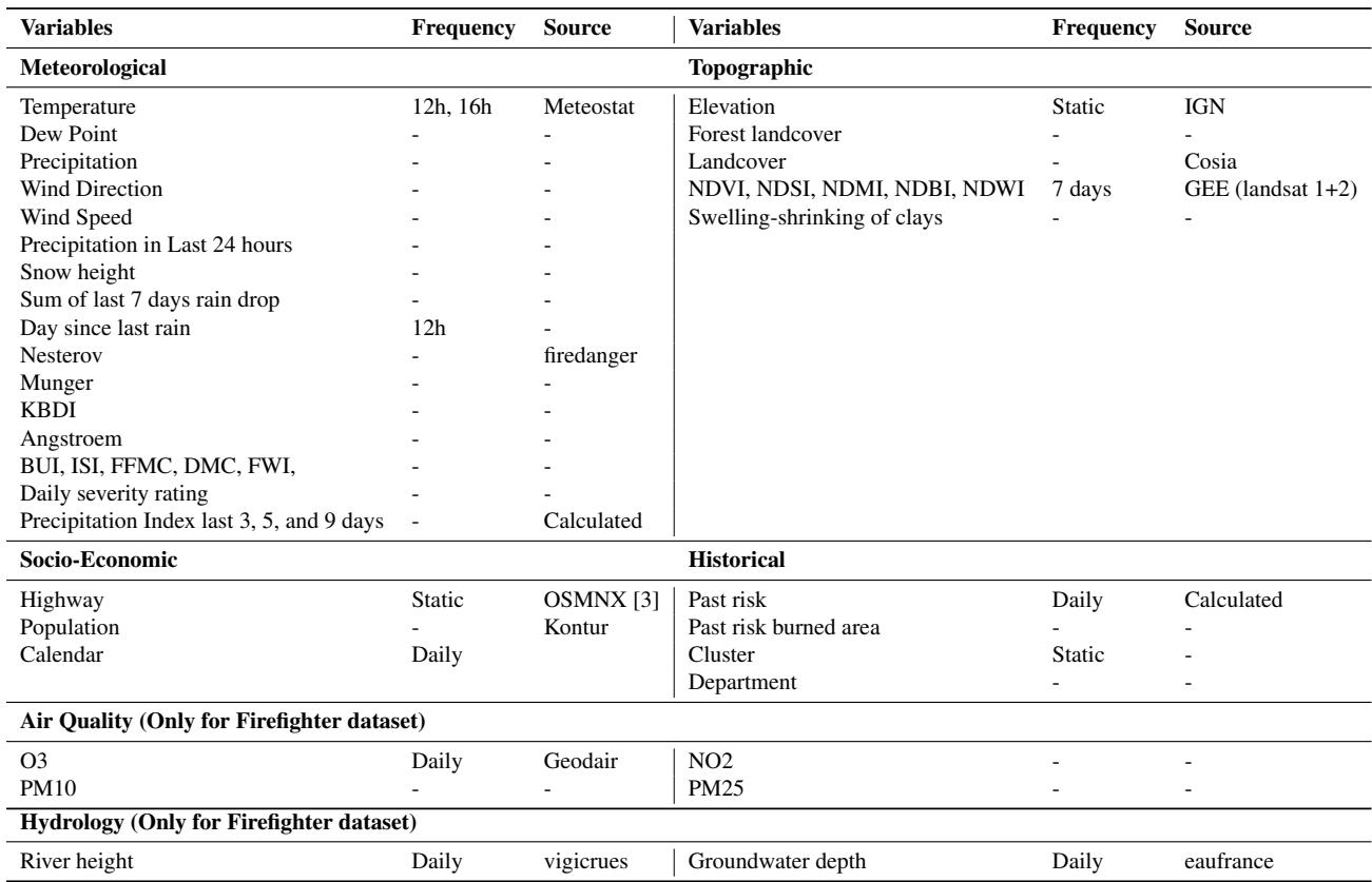
- Features come from six groups: Meteorological, Topographic, Socio‑Economic, Air Quality, Hydrological, and Historical. (Air quality and hydrological variables are added for the Firefighter dataset.) All features are transformed into a 3D raster at 2 km resolution and aggregated per pixel using average, maximum, and minimum. Low‑variance and highly correlated features are removed. The 2 km resolution is a practical compromise to account for fire‑location uncertainty; it is not required by the segmentation algorithm.
Data usage and splitting
- The datasets are split into training (2017–2021), validation (2022), and testing (2023) subsets. All preprocessing steps are fitted on the training set and then applied to the other splits.
- The Firefighter and BDIFF datasets are treated independently. The final samples consist of aggregated features and the ordinal target for a specific spatial cluster on a specific day. Segmentation is performed using only the training set.
Method
The authors propose a fire-area segmentation pipeline designed to construct optimal prediction zones based on historical fire locations, addressing the limitations of conventional grid-based discretization which fails to capture complex, non-uniform spatial patterns of fire ignitions. The method relies on unsupervised segmentation algorithms to partition the study area into clusters of a specified target size, ensuring adaptability across different departments and scales. The pipeline operates in three main stages: generating a continuous 3D signal of fire risk, detecting fire-prone areas, and merging these areas to match the target size.
Refer to the framework diagram below for a visual overview of the image-processing method.
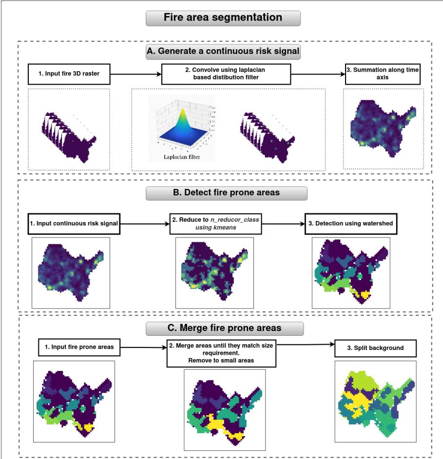
In the first stage, the authors transform the sparse and discrete raw fire occurrence raster into a continuous spatial risk surface. This is achieved by applying a Laplacian distribution-based filter to a 3D raster of fire occurrences. The filter smooths the signal based on the average duration of fire sequences within a 20 km radius, computed seasonally and regionally. Summing along the temporal axis yields a cumulative risk signal.
In the second stage, the cumulative risk is clustered into groups using K-means to reduce noise and identify main fire areas. The number of groups is controlled by a parameter that selects the intensity of the fire-prone areas. Subsequently, a watershed segmentation algorithm is applied. The authors chose watershed segmentation combined with K-means clustering because watershed naturally detects basins in the density surface, producing zones that follow the topography of fire risk, while K-means provides explicit control over the number of merged regions.
The third stage ensures that each detected fire-prone region matches a target size corresponding to the spatial scale at which predictions will be made. Zones smaller than the minimum size are merged with neighboring zones. If no valid neighbor is found, areas are expanded via dilation. Undersized zones persisting after a maximum number of dilation iterations are removed, while oversized zones are eroded. Background pixels are recursively split until all clusters reach the required size.
As shown in the figure below, the merging algorithm iteratively handles small and large clusters until all meet the required size constraints.
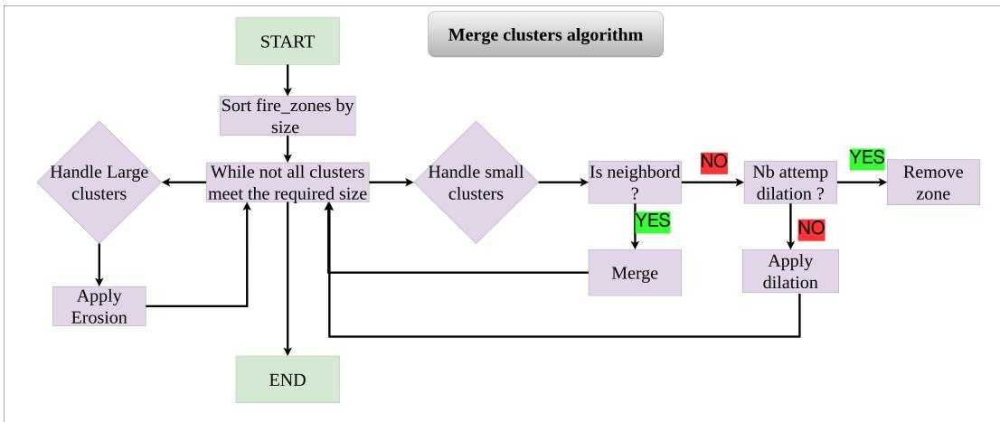
The method takes several input parameters, including scale (determining area size), intensity levels (controlling intensity thresholds), maximum dilations (specifying merge iterations), and a tolerance parameter for region size. The output is a labeled raster where each pixel belongs to a fire-zone cluster defining a prediction unit.
To validate these segmentation methods, the authors employ a training scheme where models are trained to predict daily fire risk within each cluster. They utilize fast-to-train models like gradient-boosted decision trees (XGBoost, CatBoost) to keep the hyperparameter search within a reasonable time budget. A grid-search strategy is used over the maximum dilations and intensity levels parameters to generate candidate partitions. The search grid includes max_dilations∈{1,2,3,4,5} and intensity_levels∈{2,3,4,5,6}, analyzed across scales of 0.2,0.3,0.4 degrees. To address class imbalance, different proportions of zero-class samples are tested, with a proportion of 0.3 to 0.5 proving optimal in most configurations. All experiments use a fixed random seed of 42 for reproducibility.
Experiment
The experiments train fast gradient-boosted tree models to predict daily fire risk within clusters obtained from grid-based or fire-area-based segmentation, evaluated via IoU on two wildfire datasets across multiple departments and spatial scales. Fire-area segmentation consistently outperforms the grid baseline, with the medium scale (0.3°) yielding the most reliable cross-department gains and no scenario where grid-based segmentation is better. Department-specific hyperparameter optimization is necessary to avoid performance loss, though the approach is computationally light and scalable. Overall, fire-area segmentation is a no-regret preprocessing step that enhances prediction accuracy.
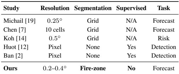
The proposed fire-zone segmentation replaces conventional grid-based spatial discretization for wildfire prediction, using an unsupervised approach that derives zones directly from historical ignition patterns. Compared to prior forecast studies that rely on regular grids, this method achieves comparable or finer resolutions (0.2–0.4°) without requiring supervised labels. The segmentation is computationally lightweight, processing a single department in under 10 seconds, though applying a single configuration across departments reduces intersection-over-union by 0.02–0.04, highlighting the importance of local tuning. All prior forecast studies in the comparison use regular grid segmentation, whereas the proposed method is the only one that creates fire-zone segments. The segmentation algorithm exhibits low computational cost: a single department at 2 km resolution processes in less than 10 seconds with a memory footprint below 2 GB, making nationwide parallelization feasible. Using a uniform segmentation configuration across different departments decreases mean IoU by 0.02–0.04, indicating that departmental wildfire patterns require localized parameter settings.
The study frames wildfire forecasting as an ordinal five-class task, with features grouped into six categories: meteorological, topographic, socio-economic, air quality, hydrological, and historical. All features are aggregated into a 2 km resolution 3D raster using average, maximum, and minimum, and the target is a five-level occurrence label created by K-means on positive fire days. Meteorological variables are sampled at 12-hour and 16-hour intervals, while satellite-derived vegetation indices refresh every 7 days, and static topographic features provide elevation and landcover context. Temperature, dew point, precipitation, and wind are recorded at 12h and 16h from Meteostat, while NDVI, NDSI, NDMI, NDBI, and NDWI are updated every 7 days from Landsat. Applying a single segmentation parameter configuration across all departments reduces mean IoU by 0.02–0.04, indicating that optimal settings are department-specific.
The dataset spans six French departments with wildfire counts ranging from 1,025 to 2,980 over varying time periods. Applying a segmentation configuration optimized on one department (Bouches-du-Rhône) to others degrades mean IoU by 0.02–0.04 for Hérault and Ain, confirming that regional heterogeneity significantly affects performance. Wildfire counts differ substantially across departments, from 1,025 in Hérault to 2,980 in Doubs, even though recording periods vary. Using a single segmentation configuration leads to a 0.02–0.04 mean IoU drop for Hérault and Ain, showing that department-specific tuning is needed.

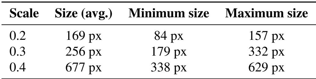
At a fixed tolerance of 0.3, cluster size distributions are non-overlapping across the three scales, satisfying the condition for the highest tolerance with no distribution overlap. Average cluster size increases monotonically with scale, from 169 pixels at scale 0.2 to 677 pixels at scale 0.4. Cluster size ranges (minimum to maximum) are completely disjoint between scales 0.2, 0.3, and 0.4, ensuring no overlap in the distributions. Average cluster size more than doubles when moving from scale 0.3 (256 pixels) to scale 0.4 (677 pixels).
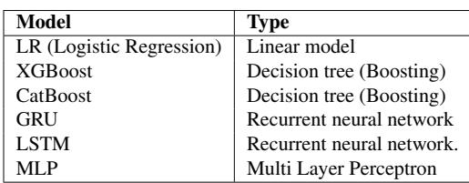
The evaluated models span linear, tree-based boosting, and recurrent neural network architectures. Tree-based boosting methods (XGBoost, CatBoost) were selected for their training speed and strong performance on tabular data, while GRU, LSTM, and MLP serve as neural network baselines. The model set includes logistic regression, two gradient-boosted decision tree models (XGBoost, CatBoost), and three neural networks (GRU, LSTM, MLP). XGBoost and CatBoost were chosen because they remain highly competitive with or outperform deep learning models on tabular data while keeping training time within a few days.
The evaluation framework replaces conventional grid-based wildfire forecasting with an unsupervised fire-zone segmentation that aggregates meteorological, topographic, and satellite features into a 2 km raster for ordinal risk prediction across six French departments. Key findings indicate that uniform segmentation parameters degrade performance by 0.02–0.04 mean IoU when transferred between departments, confirming that local ignition patterns require department-specific tuning, while cluster size distributions remain non-overlapping at scales 0.2, 0.3, and 0.4. Tree-based boosting models (XGBoost, CatBoost) are selected for their competitive accuracy and training speed on tabular data, and the lightweight segmentation processes a single department in under 10 seconds, making nationwide parallelization feasible.