Command Palette
Search for a command to run...
Spanish Traffic Aerial Imagery Dataset
Date
Size
Publish URL
Paper URL
License
CC BY 4.0
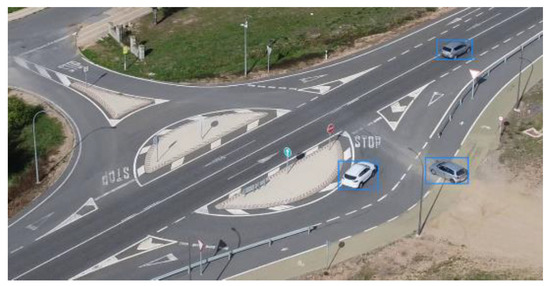
This dataset was created in 2022 by a research team from Universidad Francisco de Vitoria and Universidad Europea de Madrid in Spain. It aims to provide high-quality training data for machine vision algorithms in the field of traffic management. The relevant paper results are "Dataset: Traffic Images Captured from UAVs for Use in Training Machine Vision Algorithms for Traffic Management". It contains 15,070 frames of images taken by unmanned aerial vehicles (UAVs) covering a variety of traffic scenarios, including regional roads, urban intersections, rural roads, and different types of roundabouts. 155,328 objects are annotated in the images, of which 137,602 are cars and 17,726 are motorcycles. These images are stored in the YOLO format, which is convenient for training machine vision algorithms based on convolutional neural networks.
In order to comply with European data protection regulations, the license plate information in the dataset has been anonymized to protect personal privacy. The creation process of this dataset includes multiple steps such as data collection, image capture, vehicle annotation, anonymization, and data verification. The research team used drones such as DJI Mavic Mini 2 and Yuneec Typhoon H for image collection and took a large number of images in different scenes and conditions to ensure the diversity and richness of the data. In addition, in order to verify the effectiveness of the dataset, the research team also trained a simple neural network model and achieved good results.
The uses of this dataset are very wide. It can be used to develop and optimize traffic management systems, monitor and analyze traffic flow through images captured by drones, and thus improve traffic efficiency. In addition, it can also be used to train machine vision algorithms in autonomous driving technology to help the algorithms better identify and classify vehicles in traffic scenes. For traffic violation management, this dataset can be used to train algorithms to monitor traffic violations using drones. In terms of emergency response, this dataset can be used to train algorithms to respond quickly when traffic accidents occur and reduce casualties.
Citation
@dataset{sergio_ghisler_2021_5776219, author = {Sergio Ghisler and Javier Sánchez-Soriano and Sergio Bemposta Rosende}, title = {Traffic images captured from UAVs for use in training Machine Vision Algorithms for traffic management }, month = dec, year = 2021, publisher = {Zenodo}, version = 1, doi = {10.5281/zenodo.5776219}, url = {https://doi.org/10.5281/zenodo.5776219}, }
Build AI with AI
From idea to launch — accelerate your AI development with free AI co-coding, out-of-the-box environment and best price of GPUs.