Command Palette
Search for a command to run...
Deep Reinforcement Learning Enables Urban Fire Protection optimization. The Chinese Academy of Sciences Team Proposed a New DRL Method to Solve the Problem of Facility configuration.
In urban construction and development, geospatial optimization is crucial. It plays a key role in everything from the site selection of industrial parks to the layout of public service facilities. However, traditional solutions have many limitations. Now, deep learning technology has brought new opportunities.
Recently, at the 2025 Annual Academic Meeting of the Geographical Model and Geographical Information Analysis Committee of the Chinese Geographical Society,Dr. Liang Haojian from the Institute of Space Information Innovation of the Chinese Academy of Sciences gave a presentation on the topic of "Geospatial Optimization" with the title "Research on Optimization Method of Urban Emergency Fire Facility Configuration Based on Hierarchical Deep Reinforcement Learning".It also provides a detailed introduction from four aspects: an overview of geospatial optimization problems, research on deep learning methods for geospatial optimization problems, new explorations based on hierarchical deep reinforcement learning, and future prospects.
HyperAI has compiled and summarized Mr. Liang Haojian’s in-depth sharing without violating the original intention. The following is the transcript of the speech.
Geospatial Optimization: Deep Integration of Mathematics and Geography
Geospatial optimization is a combination of mathematical combinatorial optimization and geographic information science. It is dedicated to solving practical problems such as spatial layout and resource allocation. It has important research significance in many fields such as urban construction, industrial park site selection, and public service facility site selection.It can be expressed as an optimization problem involving decision variables, constraints and objective function.The decision variables are usually integers or 0-1 variables, as shown in the figure below.
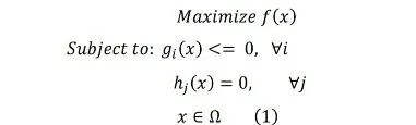
Constraint (1) represents the range of the decision variable 𝒙, which is usually an integer or a 0-1 variable.
Taking the classic p-median problem as an example,It aims to select p deployment facilities from the candidate facilities to minimize the total distance from all demand points to the nearest facility point, and is often used in public facility site selection. There are three types of traditional methods for solving spatial optimization problems, including exact algorithms, approximate algorithms, and heuristic algorithms, but they all have their own shortcomings.
* The precise algorithm can obtain the global optimal solution,However, the computational complexity is usually high, and the solution time increases exponentially with the size of the problem.For example, branch and bound method, dynamic programming, etc.
* Approximate algorithms improve solution efficiency while ensuring certain theoretical performance.However, its algorithm design is relatively complex.For example, greedy strategies, linear programming rounding and other methods.
* Heuristic algorithms can obtain better solutions in a shorter time and are suitable for large-scale complex problems.However, there is a lack of theoretical optimality guarantee.Common methods include simulated annealing, taboo search, etc.
Deep Learning Enters Geospatial Optimization
In fields such as computer vision and natural language processing, deep models have been used to replace manual algorithm design and have achieved remarkable results. So, can it be used to solve spatial optimization problems? Based on this idea, researchers have explored neural spatial optimization, with three motivations: learning faster/better heuristic methods, using data-driven fast approximation to replace complex calculations, automatically designing a general framework for new heuristic algorithms, and training DRL models with historical information to guide future planning.
Therefore, I have two major ideas for NeurSPO:
One is deep structure.Simply put, the solution is empty at the beginning, and then a point is selected each time until the target p points are selected to complete the step-by-step construction of the solution.
The second is depth improvement.Its essence is similar to algorithms such as local search, which is a method to improve solutions. Deep learning can be used to replace solutions. For example, in local search, appropriate points can be selected for exchange or optimization.
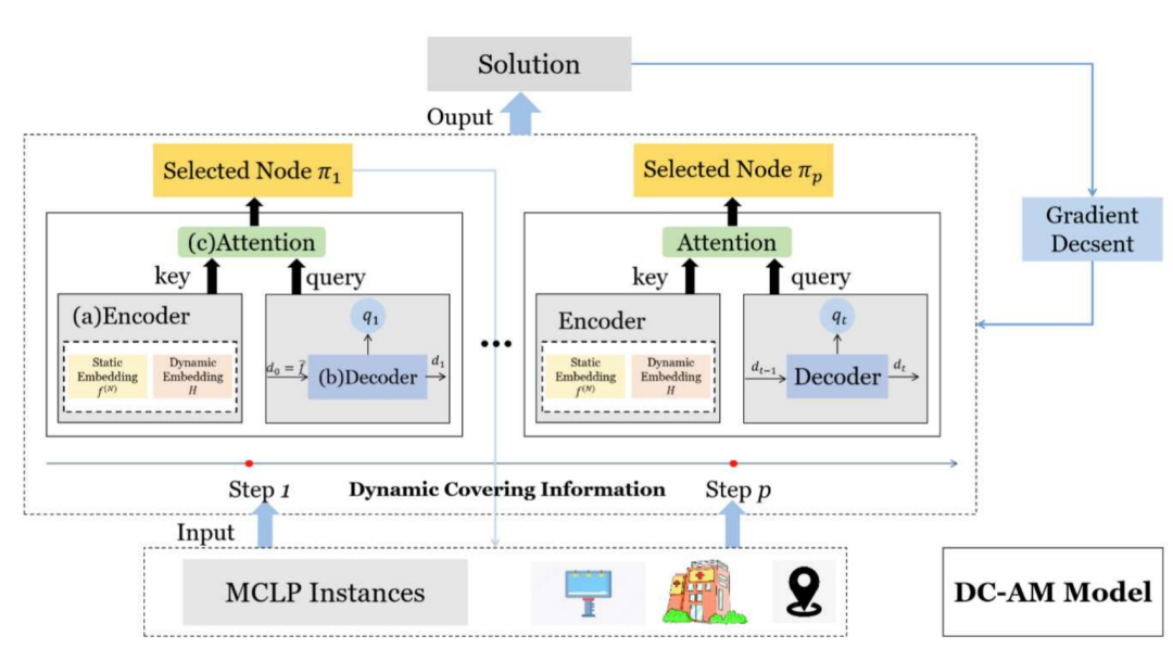
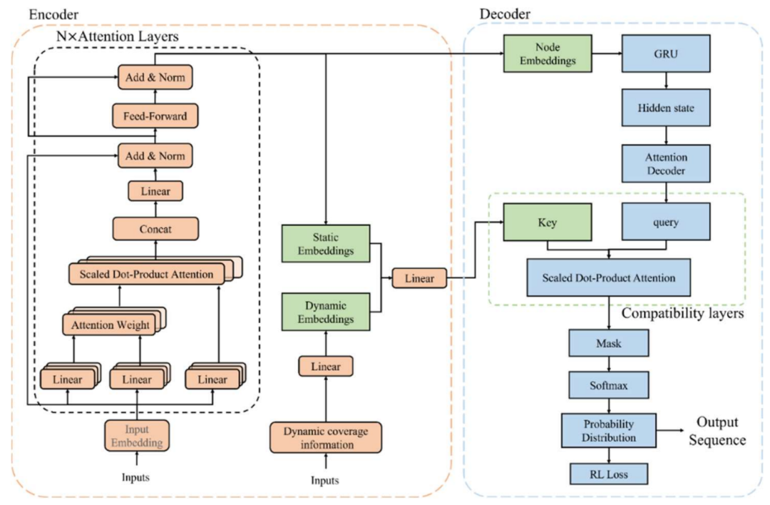
SpoNet model: Dynamic overlay attention solves the site selection problem
How to solve the target problems of p-Median, p-Center, and MCLP in exploring DRL methods? We first tried the dynamic coverage information + attention model.A unified framework for solving site selection problems, SpoNet, is proposed.Its structure mainly consists of 3 parts:
* Under the deep learning model, the agent continuously interacts with the environment and maximizes the reward through a large amount of trial and error and learning strategies, without the need to generate label information.
* The attention model enables the model to learn to focus on specific parts of the input sequence when decoding, rather than relying solely on the decoder input.
* In the process of node coverage, if a node has been covered, choosing to deploy facilities at this point may lead to reduced coverage efficiency. Under the dynamic coverage attention model, the static location coordinates of the city and the dynamic coverage status between cities are encoded, and knowledge-driven, by introducing problem-specific coverage information for encoding, the model's ability to understand spatial coverage relationships is improved, thereby accelerating the solution process. As shown in the following figure:
We applied this model to explore the layout optimization of emergency facilities in Chaoyang District, Beijing, and selected a data set of 132 emergency facilities. We assumed that the maximum service distance of each facility point was 2 kilometers.Finally, 20 points were selected as central hubs from 132 candidate emergency facilities, which covered the largest number of nodes.
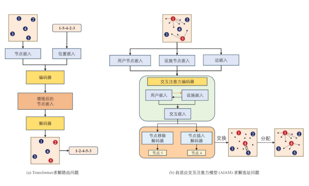
AIAM: Adaptive interactive attention model to solve the p-median problem
The local search algorithm mode of searching in the neighborhood of the current solution and trying to find a better solution is relatively mature. On this basis, we explored the deep enhancement auxiliary search.That is, based on the idea of neighborhood search, the DRL search strategy is used to achieve a fast approximation search process that replaces complex calculations.
In the path planning problem, there are different order relationships between different nodes, but the solution in the 𝒑-median problem is a subset of the facility set, resulting in different distribution relationships between user nodes and facility points. To measure this distribution relationship, we set up the interaction between "user" and "facility" and proposed an adaptive interaction attention model.
The model consists of three parts: interactive attention encoder, node removal decoder, and node insertion decoder.As shown in the following figure:
Proven,The model was able to retain 15 hospitals out of 2,162 settlements (demand sites) and 80 hospitals (candidate facility sites).The total distance from residential areas to hospitals is minimized, which proves the feasibility of the AIAM model in practical scenarios.
Layered DRL solves the problem of urban emergency firefighting facility configuration
At present, cities are developing rapidly, the frequency and complexity of emergencies continue to rise, and the problems of balancing the efficiency and functionality of urban emergency firefighting facilities have intensified. Traditional fire prediction methods are difficult to handle large-scale, high-precision data, resulting in low risk assessment accuracy, delayed response, and the layout of firefighting facilities cannot reflect urban changes and emergency needs in real time. In this context, it is urgent to introduce intelligent and dynamic fire risk prediction and emergency firefighting facilities to comprehensively improve the scientificity and efficiency of urban fire prevention and control and emergency response.
Based on this,We shift the theoretical research of deep learning frameworks toward real-life applications.In order to improve the urban fire prevention and control and emergency response capabilities, the research focuses on improving the accuracy of fire risk prediction, optimizing emergency resource allocation, and enhancing the timeliness and flexibility of emergency response. This is achieved through the following three aspects.
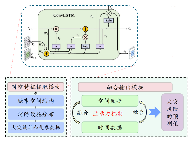
The first is the multi-dimensional spatiotemporal feature mining and fusion for urban fire risk prediction.
The spatiotemporal neural network for urban fire risk prediction is mainly composed of a spatiotemporal feature extraction module and a fusion output module. * The spatiotemporal feature extraction module automatically captures the dynamic changes of urban spatial structure, firefighting facility distribution, fire statistics and meteorological data in the forward propagation; * The fusion output module integrates spatiotemporal features through the attention mechanism and finally outputs the fire risk prediction value. As shown in the figure below.
The second is to construct an optimization model for emergency fire protection facility configuration considering uncertainty and disaster losses.
In the multi-coverage site selection, uncertain factors such as fire frequency, traffic conditions and demand distribution are introduced, and disaster losses are included in the objective function to improve the robustness of the layout plan. The changes in fire occurrence, traffic flow and demand fluctuations are described through probability distribution or interval estimation. In modeling, the fire risk is combined with historical data and geographical conditions to build a probability model, the traffic response is based on the time distribution of traffic capacity and simulation analysis, and the demand change is responded to the dynamic development of the city by setting the fluctuation range or scenario set.
The third is the hierarchical DRL method for optimizing the layout of emergency fire fighting facilities.
The algorithm adopts a hierarchical strategy to coordinate the overall layout and local adjustments of fire protection facilities. The model state includes facility distribution, fire risk and traffic conditions, and the action is the station establishment or scheduling decision at each moment.
Future Outlook: Expanding Boundaries and Continuing Innovation
The path of scientific research is always progressing. In the future, our team plans to explore more complex and practical geospatial optimization problems through interdisciplinary collaboration, combining geographic information systems, mathematical optimization methods and deep learning technology.
In this regard, I have made some thoughts and prospects from the following three aspects:
* Introduce geographic computing mechanism to enhance spatial perception ability.
The ability of AI to optimize geographic space is still being explored, and current research alone is far from enough. In the future, modeling of spatial mechanisms such as terrain, network accessibility, and connectivity will help improve the model's ability to explain geographic structures and its practical adaptability.
* Expanded to large-scale and cross-regional emergency response issues.
At present, our research is limited to the exploration of small problems, so in the future it will inevitably gradually extend to the exploration of large-scale emergency response problems, and continue to improve it to support multi-center linkage optimization at the urban agglomeration and provincial levels, so as to improve the scalability, stability and computational efficiency of the method.
* Design a more efficient DRL algorithm framework.
In the future, we can continue to explore and optimize the high/low-level strategy coordination mechanism and training process, introduce technologies such as multi-agent collaboration, asynchronous training, and causal mechanisms, and achieve more effective solving of practical problems.
In summary, the hierarchical DRL method proposed by Dr. Liang Haojian's team from the Institute of Space Information Innovation of the Chinese Academy of Sciences is an AI innovation solution in the field of geospatial optimization.By integrating the dynamic coverage attention model, the adaptive interactive attention model and the multi-dimensional spatiotemporal feature fusion technology, it not only solves the problems of delayed risk assessment and inefficient resource allocation in the layout of traditional fire-fighting facilities, but also realizes the global coordination and local optimization of the layout of emergency facilities through a layered strategy.
In the future, with the introduction of geographic computing mechanisms and the expansion of cross-regional emergency response models, this method is expected to release greater potential in the fields of large-scale urban governance and multi-center linkage optimization, and promote the deep integration and innovation of geographic space optimization and emergency management. It is believed that in the continuous exploration and innovation, the field of geographic space optimization will achieve more breakthroughs and provide stronger support for urban development and emergency management.
About the Chinese Academy of Sciences Space Information Innovation Institute
Dr. Liang Haojian is a special research assistant at the Institute of Space Information Innovation, Chinese Academy of Sciences.The main research directions are geospatial optimization, deep reinforcement learning, remote sensing big data analysis and comprehensive application of digital earth.

His team, led by researcher Wang Shaohua, has the vision of "promoting the cross-application of geospatial science and artificial intelligence to provide innovative solutions for achieving smart cities and sustainable development goals". They are committed to using advanced computing methods and artificial intelligence technologies to analyze and process spatiotemporal big data to achieve intelligent decision-making and optimization of the spatial environment.The team used technologies such as spatiotemporal big data analysis, deep learning and machine learning to carry out a number of studies such as geospatial optimization and remote sensing AI.