Command Palette
Search for a command to run...
Google Officially Responded to the follow-up of the 99 Mobile phones' Performance Art "teasing" Google Maps
What is the basis for Google Maps to judge whether there is traffic congestion? Is there any flaw in it? An artist named Simon Weckert successfully deceived Google Maps' road condition judgment through a simple experiment, creating a false "traffic jam" on an empty road. Google gave an unexpected response to this behavior.
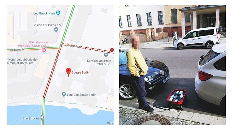
How can you trick Google Maps' real-time traffic conditions? Recently, someone used a performance art to verify the answer: all it takes is a cart and 99 mobile phones.
The day before yesterday, Google officials gave a friendly and encouraging response to this bold and avant-garde performance art.
To make Google Maps dizzy, all you need is 99 phones and a stroller
Recently, in order to "crack" the traffic function of Google Maps,An artist named Simon Weckert carried out his "interference" project on a street in Berlin.
The principle he based his experiment on was that the positioning functions of multiple mobile phones would affect the data collection of Google Maps. The purpose of the experiment was to verify whether mobile phones could affect the road conditions provided by the map.
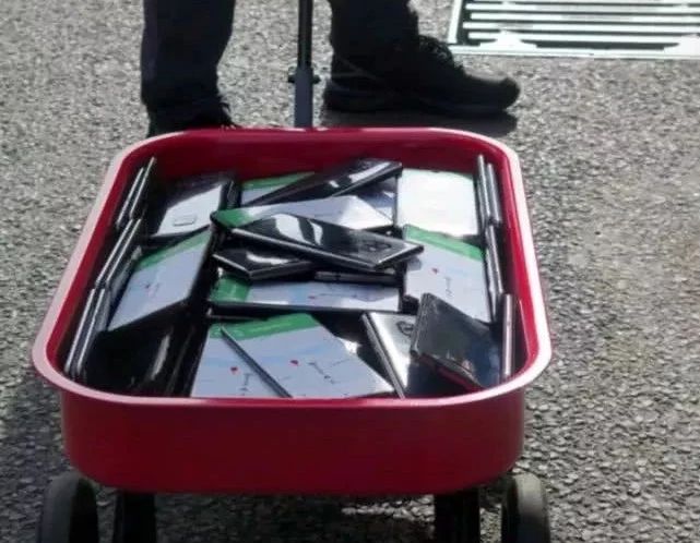
Weckert loaded a cart with 99 cell phones and set them all to navigation mode.
Then he dragged the cart slowly on the street, observed the real-time traffic conditions on the map, and recorded the whole process with video.
Simon Weckert uploaded the full video of the performance
As the activity continued for a longer period of time, the expected thing happened.As he moved back and forth, the traffic conditions on Google Maps on the empty streets began to change, slowly changing from green to yellow, to orange, and finally to deep red, indicating a severe traffic jam.
During the entire process, the actual number of vehicles on the road did not increase, and the video also shows that there were almost no vehicles passing by. However, the Google Map display indicated that the road was crowded with vehicles and advised drivers to take a detour.
That is to say,A small cart carrying 99 mobile phones moving back and forth fooled Google Maps into thinking that there were nearly a hundred cars driving on the road.
Google Maps data collection mechanism
The traffic information of most map software will refer to the GPS data uploaded by users. When users turn on GPS while using a map application, the device will anonymously package the data and send it back, and use this information to determine the traffic conditions on the road.
So in this case, the activation of navigation functions on multiple mobile phones, coupled with slow movement on the road, caused Google Maps to misjudge.

Weckert explained that the idea for the experiment came from a discovery he made during a demonstration.There were many people marching on the street at the time, and although there were no vehicles, Google Maps showed that the road was severely congested.
This observation prompted him to conduct this exploration. Weckert posted a video of the experiment on the website and explained the actual impact of this move. Through this trick, the originally smooth roads in the map application became seriously congested sections on the map, thus affecting people's travel choices and methods.
In order to make this project more eye-catching, he chose to release the results on the 15th anniversary of the release of Google Maps, and deliberately passed by Google's Berlin headquarters when shooting, bringing it a red "congestion".

Weckert said that when people think that data is “objective, clear, and freely interpretable,” this concept can lead to “blindness.”He hopes to expose the drawbacks of people's excessive reliance on data.
In the face of "provocation", Google responded like this
Google clarified and responded to Weckert's behavior on February 4.
A Google spokesperson said:He said he was happy to see such creative approaches and would encourage such behavior. He also said he was willing to accept user opinions to make Google Maps better.
He said that under normal use, Google Maps does use information from the user's mobile phone to extract data from the device running the Google Maps App as a basis for traffic congestion.
But the spokesperson also joked,Google has not yet "completely figured out" how to distinguish traffic data from trolleys, and Weckert's experiment took advantage of this rare and special situation.
In addition, Google said it would consider the blunder caused by this result and use it to improve the way Google Maps handles traffic data.

Here is a translation of Google’s response:
"Whether by car, carriage or camel,We love seeing creative uses of Google Maps because it helps us make our mapping work better.
Traffic data on Google Maps is continuously updated thanks to information from a variety of sources, including aggregated, anonymized data from users of location services, and contributions from the Google Maps community.
While we haven’t completely solved the issue of carriage travel, we have launched the ability to differentiate between cars and motorcycles in several countries, including India, Indonesia, and Egypt."
In the view of Google officials, the problems mentioned by Weckert may be solved in subsequent updates.
-- over--